IMAGES TAKEN NEAR TO
Hylstone Crescent, WOLVERHAMPTON, WV11 3EZ
Introduction
This page details the photographs taken nearby to Hylstone Crescent, WV11 3EZ by members of the Geograph project.
The Geograph project started in 2005 with the aim of publishing, organising and preserving representative images for every square kilometre of Great Britain, Ireland and the Isle of Man.

There are currently over 7.5m images from over14,400 individuals and you can help contribute to the project by visiting https://www.geograph.org.uk
Image Map
Images are licensed for reuse under creativecommons.org/licenses/by-sa/2.0
Notes
- Clicking on the map will re-center to the selected point.
- The higher the marker number, the further away the image location is from the centre of the postcode.
Image Listing (28 Images Found)
Images are licensed for reuse under creativecommons.org/licenses/by-sa/2.0
Image
Details
Distance
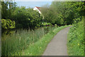
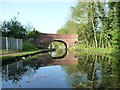
2
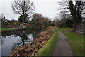
Wyrley & Essington Canal, west of Moat House Bridge
Tree-lined and surrounded by houses.
Image: © Christine Johnstone
Taken: 7 May 2018
0.08 miles
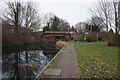
3
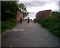
Moathouse Lane bridge over the Essington and Wyrley canal
No longer a drivable road; the bridge now carries a cycleway and footpath.
Image: © Richard Law
Taken: 22 Jul 2011
0.10 miles
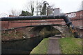
4
Wyrley & Essington Canal at Moat House Bridge
Image: © Ian S
Taken: 16 Dec 2021
0.10 miles
5
Wyrley & Essington Canal at Moat House Bridge
Image: © Ian S
Taken: 16 Dec 2021
0.10 miles
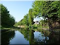
6
Wyrley & Essington Canal at Moat House Bridge
Image: © Ian S
Taken: 16 Dec 2021
0.10 miles
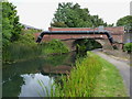
7
Moat House Bridge, from the north-east
Carrying Moathouse Lane over the Wyrley & Essington Canal.
Image: © Christine Johnstone
Taken: 7 May 2018
0.10 miles
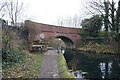
8
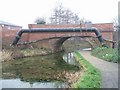
Moathouse Lane Bridge
This bridge carries a footpath and cycleway over the Wyrley and Essington Canal. The canal by following the contours has no locks on this section but takes a very meandering route hence its nickname 'Curly Wyrley'.
This bridge has been partially rebuilt and extended as can be seen from the change in brick colour.
Image: © John M
Taken: 26 Dec 2006
0.11 miles
9
Canal Bridge at the bottom of Hyde Road
This bridge was locally known as the "Dump Bridge" in the 1970s , as there was lots of rubbish was often dumped here. This is actually Moathouse Lane Bridge. There was once a Council Depot on the other side of the bridge and I vaguely remember seeing skips here.
Image: © A Holmes
Taken: 1 Jun 2002
0.11 miles
10
Wyrley & Essington Canal towards Moat House Bridge
Image: © Ian S
Taken: 16 Dec 2021
0.12 miles