IMAGES TAKEN NEAR TO
Queen Street, WALSALL, WS9 9LJ
Introduction
This page details the photographs taken nearby to Queen Street, WS9 9LJ by members of the Geograph project.
The Geograph project started in 2005 with the aim of publishing, organising and preserving representative images for every square kilometre of Great Britain, Ireland and the Isle of Man.

There are currently over 7.5m images from over14,400 individuals and you can help contribute to the project by visiting https://www.geograph.org.uk
Image Map
Images are licensed for reuse under creativecommons.org/licenses/by-sa/2.0
Notes
- Clicking on the map will re-center to the selected point.
- The higher the marker number, the further away the image location is from the centre of the postcode.
Image Listing (44 Images Found)
Images are licensed for reuse under creativecommons.org/licenses/by-sa/2.0
Image
Details
Distance
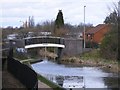
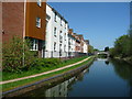
2
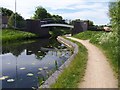
Hollanders Bridge - Daw End Canal
On the far right is the beginnings of a building site. Soon after there are new apartments built right up to the towpath edge.
Image: © Adrian Rothery
Taken: 22 May 2007
0.07 miles
3
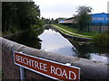
Beechtree Road View
The Daw End Branch Canal viewed from a bend in the road.
Image: © Gordon Griffiths
Taken: 15 Sep 2008
0.09 miles
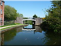
5
Hollanders Bridge
The view of the footbridge from the Daw End Branch Canal, Walsall Wood..
Image: © Gordon Griffiths
Taken: 28 Mar 2010
0.09 miles
6
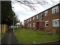
Footpath and flats off Beech Tree Road, Walsall Wood
Beech Tree Road can be seen at the far end of the footpath; the flats have their own small car park (in which the photographer is standing), accessed from King Street.
Image: © Richard Vince
Taken: 31 Jan 2015
0.10 miles
7
Hollanders Bridge, from the south
Crossing the Daw End Branch of the Wyrley & Essington Canal. Once a road bridge, but now blocked by bollards.
Image: © Christine Johnstone
Taken: 6 May 2018
0.10 miles
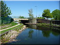
9
Canalside housing off Boatman's Lane, Walsall Wood
Alongside the Daw End Branch of the Wyrley & Essington Canal, between Lathams and Hollanders Bridges.
Image: © Christine Johnstone
Taken: 6 May 2018
0.11 miles
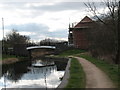
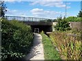
10
Daw End Branch, south of Walsall Wood Bridge
The water is so clear you can see plants growing under the surface. This is partly due to less pollution, and partly due to so few boats on the move.
Image: © Christine Johnstone
Taken: 6 May 2018
0.12 miles