IMAGES TAKEN NEAR TO
Lichfield Road, WALSALL, WS4 1EN
Introduction
This page details the photographs taken nearby to Lichfield Road, WS4 1EN by members of the Geograph project.
The Geograph project started in 2005 with the aim of publishing, organising and preserving representative images for every square kilometre of Great Britain, Ireland and the Isle of Man.

There are currently over 7.5m images from over14,400 individuals and you can help contribute to the project by visiting https://www.geograph.org.uk
Image Map
Images are licensed for reuse under creativecommons.org/licenses/by-sa/2.0
Notes
- Clicking on the map will re-center to the selected point.
- The higher the marker number, the further away the image location is from the centre of the postcode.
Image Listing (24 Images Found)
Images are licensed for reuse under creativecommons.org/licenses/by-sa/2.0
Image
Details
Distance
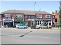
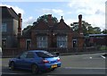
3
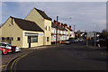
Rushall Library and War Memorial
A small parish on the Walsall to Lichfield road. Its main industry was the mining of coal and limestone.
Image: © John M
Taken: 21 Oct 2006
0.02 miles
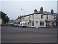
4
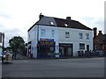
Parade of shops
The shops beside the library date from 1938.
Image: © John M
Taken: 22 May 2010
0.02 miles
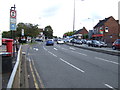
8
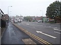
Pelsall Lane, Rushall
A stretch of the B4154 west of Lichfield Road.
Image: © Stephen McKay
Taken: 5 Apr 2016
0.05 miles
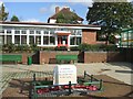
9
School in Rushall
This looks like an old school with separate entrances for boys and girls.
Image: © John M
Taken: 21 Oct 2006
0.05 miles
10
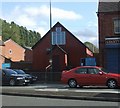
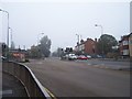
Christ the King Church in Rushall
Situated on the busy Walsall to Lichfield Road in Rushall.
Image: © John M
Taken: 21 Oct 2006
0.05 miles