IMAGES TAKEN NEAR TO
Maynard Drive, DROITWICH, WR9 7JT
Introduction
This page details the photographs taken nearby to Maynard Drive, WR9 7JT by members of the Geograph project.
The Geograph project started in 2005 with the aim of publishing, organising and preserving representative images for every square kilometre of Great Britain, Ireland and the Isle of Man.

There are currently over 7.5m images from over14,400 individuals and you can help contribute to the project by visiting https://www.geograph.org.uk
Image Map
Images are licensed for reuse under creativecommons.org/licenses/by-sa/2.0
Notes
- Clicking on the map will re-center to the selected point.
- The higher the marker number, the further away the image location is from the centre of the postcode.
Image Listing (20 Images Found)
Images are licensed for reuse under creativecommons.org/licenses/by-sa/2.0
Image
Details
Distance
1
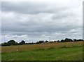
Construction Machinery ready to build Copcut Rise
A large housing development which will turn Village into Urban fringe.
In the parish of Salwarpe but soon to be in the town of Droitwich.
Image: © Jeff Gogarty
Taken: 21 Jun 2015
0.13 miles
2

Copcutt Rise under construction
A new housing development on the southern side of Droitwich outside of the ring road. http://www.copcutrisedroitwich.co.uk/
Image: © Jeff Gogarty
Taken: 13 Nov 2016
0.14 miles
3
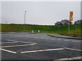
Junction on Joynes Road ready for further development
The road is also known as Copcut Boulevard and leads to a recent housing development on the edge of Droitwich. It is in the Parish of Salwarpe but does not have any direct road connection to the village.
Image: © Jeff Gogarty
Taken: 26 Dec 2021
0.16 miles
4

Copcut Rise taking shape
I cannot guarantee the exact location at the moment but it is this area. The roads are in place so the development will progress rapidly now. Image shows the first stage.
Image: © Jeff Gogarty
Taken: 26 Aug 2016
0.17 miles
5
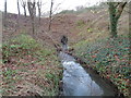
Copcut Stream, Droitwich disappearing into a culvert
The culvert takes in under the A38 (Roman Way) and it used to reappear flowing through allotments but the other side of Roman Way is being developed for housing and I do not know how far this extends.
Image: © Jeff Gogarty
Taken: 26 Dec 2015
0.20 miles
6
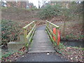
Footbridge over the Copcut Stream, Droitwich
Image: © Jeff Gogarty
Taken: 26 Dec 2015
0.20 miles
7
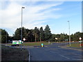
New roundabout on the Roman Way (A38), Droitwich
This is for the new housing development at Copcut Rise.
Image: © Jeff Gogarty
Taken: 26 Aug 2016
0.22 miles
8
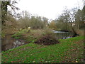
Pond by the Copcut Stream, Droitwich (3)
The stream runs to the left of the small island.
Image: © Jeff Gogarty
Taken: 26 Dec 2015
0.22 miles
9
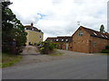
Copcut House, Copcut Lane
Detached house, Freehold , 7 Beds, 6 Baths, 7 Receps
Like most houses on Copcut Lane for sale or recently been sold.
Image: © Jeff Gogarty
Taken: 21 Jun 2015
0.22 miles
10
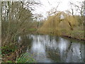
Pond by the Copcut Stream, Droitwich (2)
Image: © Jeff Gogarty
Taken: 26 Dec 2015
0.23 miles