IMAGES TAKEN NEAR TO
Wey Close, DROITWICH, WR9 0RB
Introduction
This page details the photographs taken nearby to Wey Close, WR9 0RB by members of the Geograph project.
The Geograph project started in 2005 with the aim of publishing, organising and preserving representative images for every square kilometre of Great Britain, Ireland and the Isle of Man.

There are currently over 7.5m images from over14,400 individuals and you can help contribute to the project by visiting https://www.geograph.org.uk
Image Map
Images are licensed for reuse under creativecommons.org/licenses/by-sa/2.0
Notes
- Clicking on the map will re-center to the selected point.
- The higher the marker number, the further away the image location is from the centre of the postcode.
Image Listing (47 Images Found)
Images are licensed for reuse under creativecommons.org/licenses/by-sa/2.0
Image
Details
Distance
1
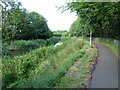
Cycle path by Droitwich Barge Canal
Part of National Cycle Route 46
Image: © Jeff Gogarty
Taken: 30 Jul 2015
0.08 miles
2
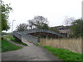
Droitwich Barge Canal, Valley Way Bridge
Image: © Chris Allen
Taken: 20 Apr 2008
0.09 miles
3
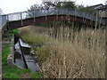
Droitwich Barge Canal, Valley Way bridge
This foot bridge is not seen on the Landranger map. There is an overflow weir to the Salwarpe under the approach ramp.
Image: © Chris Allen
Taken: 20 Apr 2008
0.09 miles
4
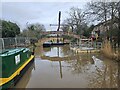
Demolition of Droitwich Canal Bridge 10 - Jan 2024
Image: © Thomas Roberts
Taken: 25 Jan 2024
0.10 miles
5

Valley Way Footbridge, Droitwich Barge Canal
Bridge no 10, counting up from Hawford Junction, is a footbridge on the outskirts of Droitwich Spa.
Image: © Stephen McKay
Taken: 28 Oct 2015
0.10 miles
6

Footbridge across the Barge Canal near Droitwich Spa, Worcestershire
The bridge (No 10) allows access from the housing estate off to the left and the playing fields off to the right.
Image: © Roger D Kidd
Taken: 23 Jun 2013
0.10 miles
7
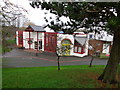
St Joseph's RC Primary School, Droitwich
Image: © Jeff Gogarty
Taken: 1 Jan 2016
0.11 miles
8
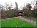
Safe bridge under railway, Droitwich
Image: © Jeff Gogarty
Taken: 1 Jan 2016
0.14 miles
9
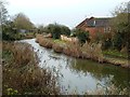
Droitwich Canal
Viewed from Siding Lane Bridge on a chilly December morning. There was a lot of thin ice on the water surface.
Image: © Mary and Angus Hogg
Taken: 6 Dec 2012
0.15 miles
10
Cycle route dips under the railway
Cyclists keep on the right as we face it. A very useful route in Droitwich, Worcestershire joining the Chawson Estate to Ombersley Way. It is a much longer route by car.
Image: © Jeff Gogarty
Taken: 25 Oct 2015
0.15 miles