IMAGES TAKEN NEAR TO
Oakmont Drive, WORCESTER, WR5 1PS
Introduction
This page details the photographs taken nearby to Oakmont Drive, WR5 1PS by members of the Geograph project.
The Geograph project started in 2005 with the aim of publishing, organising and preserving representative images for every square kilometre of Great Britain, Ireland and the Isle of Man.

There are currently over 7.5m images from over14,400 individuals and you can help contribute to the project by visiting https://www.geograph.org.uk
Image Map
Images are licensed for reuse under creativecommons.org/licenses/by-sa/2.0
Notes
- Clicking on the map will re-center to the selected point.
- The higher the marker number, the further away the image location is from the centre of the postcode.
Image Listing (642 Images Found)
Images are licensed for reuse under creativecommons.org/licenses/by-sa/2.0
Image
Details
Distance
1

Stableford development, Worcester
The green strip is over one of the oil pipelines that travel around the country.
Image: © Chris Allen
Taken: 3 Sep 2023
0.01 miles
2
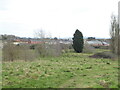
Leopard Hill, Worcester
Looking to the Stableford development from Leopard Hill.
Image: © Chris Allen
Taken: 6 Mar 2021
0.01 miles
3
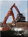
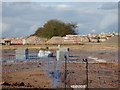
Housing development, Worcester
Off Newtown road and near the service reservoir. Quite close to one of the highest points in Worcester. The excavators look like they could be engaged in some sort of courtship dance.
Image: © Chris Allen
Taken: 15 Jul 2019
0.01 miles
4
Housing development off Newtown Road, Worcester
A new housing development that is accessed off a bridleway. It is currently only single track by Newtown Road but perhaps it is intended to widen it to the fence line of the properties on Aconbury Close.
Image: © Chris Allen
Taken: 21 Aug 2019
0.02 miles
5
View from Leopard Hill, Worcester
The building site in the mid distance is the Stableford development by Elan Homes while the chimney in the background is on Worcestershire Royal Hospital.
Image: © Chris Allen
Taken: 18 Aug 2020
0.02 miles
6

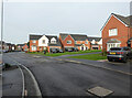
Stableford development from Leopard Hill
New houses being built on a site off Newtown Road, Worcester. A service reservoir is seen to the left.
Image: © Chris Allen
Taken: 18 Aug 2020
0.02 miles
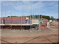
7
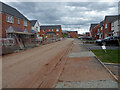
Oakmont Drive, Stableford development, Worcester
The street signs have yet to go up but Google Maps show this to be Oakmont Drive. The house on the left is still being finished.
Image: © Chris Allen
Taken: 27 Mar 2021
0.02 miles
8
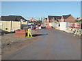
Housing development off Newtown Road
Seen from the bridleway that is also appears destined to become the main (only?) vehicular access to this new development. It cannot be too long before the show house(s) opens. That is assuming there will be a show house.
Image: © Chris Allen
Taken: 1 Dec 2019
0.02 miles
9
Oakmont Drive, Stableford Development, Worcester
Image: © Chris Allen
Taken: 26 Nov 2022
0.02 miles
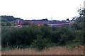
10
New housing development off Newtown Road, Worcester
Works had recently extended into this part of the field that had remained untouched. In the right background can be seen houses that are up to the top of the ground floor level.
Image: © Chris Allen
Taken: 7 Sep 2019
0.02 miles