IMAGES TAKEN NEAR TO
Trotshill Lane East, WORCESTER, WR4 0AT
Introduction
This page details the photographs taken nearby to Trotshill Lane East, WR4 0AT by members of the Geograph project.
The Geograph project started in 2005 with the aim of publishing, organising and preserving representative images for every square kilometre of Great Britain, Ireland and the Isle of Man.

There are currently over 7.5m images from over14,400 individuals and you can help contribute to the project by visiting https://www.geograph.org.uk
Image Map
Images are licensed for reuse under creativecommons.org/licenses/by-sa/2.0
Notes
- Clicking on the map will re-center to the selected point.
- The higher the marker number, the further away the image location is from the centre of the postcode.
Image Listing (140 Images Found)
Images are licensed for reuse under creativecommons.org/licenses/by-sa/2.0
Image
Details
Distance
1
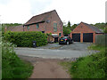
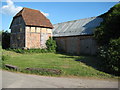
The Old Granary, Trotshill Lane East, Worcester
Seen from a path that runs past allotments to this former through road that has now been transected by the bypass. This is one of the pre-existing buildings from before the construction of the large Warndon Villages development that it is on the edge of.
Image: © Chris Allen
Taken: 22 May 2021
0.04 miles
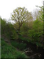
2
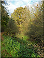
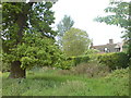
A sylvan corner at Trotshill
There are some green corners in and around the Warndon Villages development and the Trotshill areas is one of the surviving corners from before development.
Image: © Chris Allen
Taken: 12 Nov 2020
0.04 miles
3
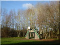
Play area near Trotshill Farm
In the Lyppard area of Warndon Villages. The farm is a pre-existing set of buildings at the edge of much new development.
Image: © Chris Allen
Taken: 1 Dec 2019
0.04 miles
4
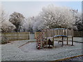
Too cold for play
A popular equipped play area at the end of Trotshill Lane looking pretty bleak in a deep hoar frost
Image: © Andrew Darge
Taken: 7 Dec 2010
0.05 miles
5
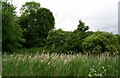
Trotshill manor?
Pathfinder 996 revised 1992 marks this as Trotshill with two buildings and three ponds . The path I am on is marked but not as a footpath . All this is before the A4440 relief road and the Warndon villages housing were built (mapped).
Image: © Andrew Darge
Taken: 22 May 2009
0.05 miles
6
Trotshill Farm
Once clearly a prosperous farm on the outskirts of Worcester the house was for a time offices for the development of Warndon villages now a stylish home. The farm buildings have all been converted into attractive houses.
Image: © Andrew Darge
Taken: 27 May 2009
0.05 miles
7
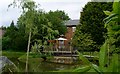
Pond in Trotshill hamlet
Fenced off from the road, it is full of bulrush and reed; a shadow of its former self I guess .
Image: © Andrew Darge
Taken: 27 May 2009
0.05 miles
8
Trotshill Farm, Worcester
The timber-frame barn stands on staddle stones which keep rats out.
Image: © Philip Halling
Taken: 27 May 2010
0.06 miles
9

Rural idyll? - Worcester
This apparent rural idyll with a pond and a former farm is at Trotshill. It is inside the bypass (A4440) and partly surrounded by modern housing. In the background is the construction site of yet another industrial unit/warehouse. The roar of the M5 can also be heard in the right conditions.
Image: © Chris Allen
Taken: 13 Dec 2019
0.06 miles
10
Sylvan setting
A rather striking tree amidst the housing estates of Warndon Villages.
Image: © Chris Allen
Taken: 24 Apr 2010
0.06 miles