IMAGES TAKEN NEAR TO
Ombersley Road, WORCESTER, WR3 7SQ
Introduction
This page details the photographs taken nearby to Ombersley Road, WR3 7SQ by members of the Geograph project.
The Geograph project started in 2005 with the aim of publishing, organising and preserving representative images for every square kilometre of Great Britain, Ireland and the Isle of Man.

There are currently over 7.5m images from over14,400 individuals and you can help contribute to the project by visiting https://www.geograph.org.uk
Image Map
Images are licensed for reuse under creativecommons.org/licenses/by-sa/2.0
Notes
- Clicking on the map will re-center to the selected point.
- The higher the marker number, the further away the image location is from the centre of the postcode.
Image Listing (78 Images Found)
Images are licensed for reuse under creativecommons.org/licenses/by-sa/2.0
Image
Details
Distance
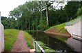
1
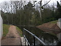
Droitwich Barge Canal emerging from under the A449
The canal has now been dredged and the earth dam that was more or less at the tail of the embankment has been excavated out.
Image: © Chris Allen
Taken: 10 Apr 2010
0.03 miles
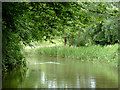
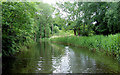
2
Droitwich Barge Canal
Some dredging will be needed here, as elsewhere, before the canal can re-open.
Image: © P L Chadwick
Taken: 14 Jun 2010
0.03 miles
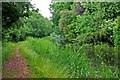
3
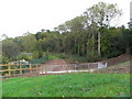
Line of Droitwich Barge Canal
From the verge of the A449 looking at the canal coming from Droitwich. The line of reeds denotes the line of the canal and it dives into a narrow culvert just below the fence by the nearest tall tree. The embankment has been cleared, presumably, ahead of the forthcoming work to restore the canal to a navigable state for vessels bigger than a toy submarine.
Image: © Chris Allen
Taken: 6 Apr 2008
0.03 miles
4
Droitwich Barge Canal
A rural scene, but the busy A449 dual carriageway road is very nearby.
Image: © P L Chadwick
Taken: 14 Jun 2010
0.04 miles
5
The Droitwich Barge Canal approaching the A449
Compare this with Image The line of trees on the right still marks the line of the weed choked canal. The metal fence is over the portal of the new tunnel under the A449. The new cut is between the portal and a bund in front of the weeds. A little water can be seen through the railings. I understand that the Barge Canal from the Severn to Droitwich is to be full navigable before the Junction Canal and that this may happen during the Winter of 2009/10. The lock are all just about done and the major remaining job is to complete dredging all the pounds. Some dredging of the section between Droitwich and lock No. 1 has been undertaken but I haven't photographed it.
Image: © Chris Allen
Taken: 10 Oct 2009
0.05 miles
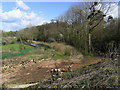
6
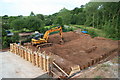
Restoration of Droitwich Barge Canal
The line of the canal is seen in front of the trees on the right. The sheet piling marks one edge. The concrete slab indicates the tunnel under the A449. This has been one major civil engineering project. The locals will be very glad when both carriageways of the A449 are restored. The work was for 27 weeks but is subject to some slippage.
Image: © Chris Allen
Taken: 13 Jun 2009
0.06 miles
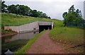
7
Droitwich Barge Canal after leaving tunnel under the A449 road
This is the view on leaving the tunnel in the direction of Droitwich.
Image
Image: © P L Chadwick
Taken: 14 Jun 2010
0.06 miles
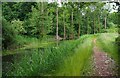
8
Droitwich Barge Canal near Hawford, Worcestershire
The restored Droitwich Barge Canal re-opened to boats on 11 September 2010. The linked Droitwich Junction Canal up to Hanbury was further delayed until 1 July 2011.
Image: © Roger D Kidd
Taken: 23 Jun 2013
0.06 miles
9
Droitwich Barge Canal near Hawford, Worcestershire
Looking towards a rebuilt part of the canal, which tunnels under the wide A449 road just out of sight ahead.
The restored Droitwich Barge Canal re-opened to boats on 11 September 2010. The linked Droitwich Junction Canal up to Hanbury was further delayed until 1 July 2011.
Image: © Roger D Kidd
Taken: 21 Jun 2013
0.07 miles
10
Droitwich Barge Canal approaching tunnel under A449 road
Image: © P L Chadwick
Taken: 14 Jun 2010
0.07 miles