IMAGES TAKEN NEAR TO
Benton Close, MALVERN, WR14 4LL
Introduction
This page details the photographs taken nearby to Benton Close, WR14 4LL by members of the Geograph project.
The Geograph project started in 2005 with the aim of publishing, organising and preserving representative images for every square kilometre of Great Britain, Ireland and the Isle of Man.

There are currently over 7.5m images from over14,400 individuals and you can help contribute to the project by visiting https://www.geograph.org.uk
Image Map (Loading...)


Getting Data...Please wait
Leaflet Map data © OpenStreetMap
Images are licensed for reuse under creativecommons.org/licenses/by-sa/2.0
Notes
- Clicking on the map will re-center to the selected point.
- The higher the marker number, the further away the image location is from the centre of the postcode.
Image Listing (271 Images Found)
Images are licensed for reuse under creativecommons.org/licenses/by-sa/2.0
Image
Details
Distance
1
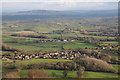
Upper Welland
Upper Welland viewed from on top of the Malvern Hills, beyond the Severn valley Bredon Hill can be seen, along with Dumbleton Hill and Aldterton Hill to the right with the Cotswold escarp as a backdrop.
Image: © Philip Halling
Taken: 18 Dec 2011
0.01 miles
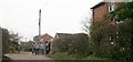
2
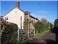
Watery Lane, Upper Welland
A 12 ft wide "Private Road or Carriage Way" as defined by the Welland Inclosure Act of 1851. still unmade and lit by gas lamps until a year or two ago.
Image: © Bob Embleton
Taken: 13 Nov 2005
0.02 miles
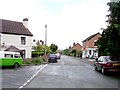
3
Upper Welland
Looking down the Upper Welland Road towards what was until very recently "The Hawthorns" public house. So named because of the hedges planted in the area after the open common land was inclosed in the 185os.
Image: © Bob Embleton
Taken: 21 May 2006
0.02 miles
4
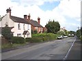
Upper Welland
Looking up the Upper Welland Road towards the Post Office and Stores. In the distance is the southern peak of Pinnacle Hill. The house on the left blessed with wisteria in bloom was once the village Co-op.
Image: © Bob Embleton
Taken: 21 May 2006
0.02 miles
5
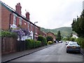
Upper Welland
Looking down the Upper Welland Road from close to the junction with Chase Road. The white house on the left was once the post office. This is now housed inside the village shop on the right.
Image: © Bob Embleton
Taken: 21 May 2006
0.02 miles
6

Upper Welland from British Camp
Looking down on the village of Upper Welland with Little Malvern Priory closer. A well marked public footpath runs across the unharvested wheat.
Image: © Bob Embleton
Taken: 28 Jul 2006
0.02 miles
7
Watery Lane on Christmas Day 2006
Before 1851 this was a track across Lower Assarts Common. After the 1851 Welland Inclosure Act this was a 12ft wide Private Road or Carriageway providing access to the newly inclosed parcels of land. It is still an unadopted track dropping down to the stream where cattle were once watered.
Image: © Bob Embleton
Taken: 25 Dec 2006
0.02 miles
8
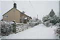
Watery Lane in the February Snow
A blanket of wet (crunchy under foot) snow. Very fine snow fell from 3 am to 12 noon with no large snow flakes. Compare with Image
Image: © Bob Embleton
Taken: 8 Feb 2007
0.02 miles
9
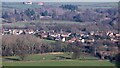
Upper Welland
Viewed from Broad Down on the Malvern Hills.
The village has developed from a triangular piece of common land known as Lower Assart before the Welland Inclosure Act of 1851 handed the land over to established land owners of Welland parish.
The common land started to have houses with large plots of land built on it. These have continuously been infilled over the last 160 years.
The rough land with many evergreen trees is the St Wulstan's Nature Reserve on the site of the hospital built for the expected D-Day casualties in the Second World War.
It later became a very successful rehabilitation mental hospital.
Shuttlefast Farm is near the top of the picture.
Image: © Bob Embleton
Taken: 16 Jan 2012
0.03 miles
10
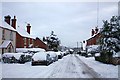
Upper Welland Road in the snow
Looking down through the village.
No snow ploughs or gritters have managed to get through today.
Image: © Bob Embleton
Taken: 6 Jan 2010
0.03 miles