IMAGES TAKEN NEAR TO
Atyeo Close, MALVERN, WR14 2QD
Introduction
This page details the photographs taken nearby to Atyeo Close, WR14 2QD by members of the Geograph project.
The Geograph project started in 2005 with the aim of publishing, organising and preserving representative images for every square kilometre of Great Britain, Ireland and the Isle of Man.

There are currently over 7.5m images from over14,400 individuals and you can help contribute to the project by visiting https://www.geograph.org.uk
Image Map
Images are licensed for reuse under creativecommons.org/licenses/by-sa/2.0
Notes
- Clicking on the map will re-center to the selected point.
- The higher the marker number, the further away the image location is from the centre of the postcode.
Image Listing (52 Images Found)
Images are licensed for reuse under creativecommons.org/licenses/by-sa/2.0
Image
Details
Distance
1
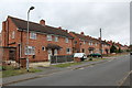
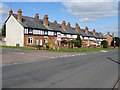
Langland Avenue, Sherrards Green, Malvern
Part of the post-war council house building programme which saw 500 council houses built in 5 years.
Not much of an avenue 60 years on.
Note how the front gardens having been given over to the parking of cars.
Image: © Bob Embleton
Taken: 8 Sep 2011
0.03 miles
2
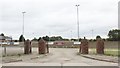
Entrance gateway to Malvern Town Football Club
Interesting brick and Malvern Granite gate pillars.
Image: © Bob Embleton
Taken: 8 Sep 2011
0.05 miles
3
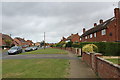
Orford Way, Sherrards Green, Malvern
Part of the post-war council house construction programme.
The 500th council house to be finished in five years is just visible
(with the cream coloured front on the left-hand side of the road).
The name Orford probably reflects Malvern's radar research connection with Orford Ness.
Image: © Bob Embleton
Taken: 8 Sep 2011
0.06 miles
4
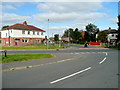
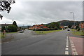
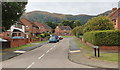
Road junction in Sherrard's Green
The intersection of Langland Avenue with Madresfield Road.
Image: © Jonathan Billinger
Taken: 1 Oct 2009
0.07 miles
5
Graham Terrace
Graham Terrace on Madresfield Road.
Image: © Philip Halling
Taken: 31 Mar 2020
0.07 miles
6
Sherrards Green Road - Madresfield Road junction
Taken from the Langland Avenue junction.
Madresfield Road heads straight towards Great Malvern and the Malvern Hills.
Sherrards Green tapers off to the left towards Barnards Green.
Image: © Bob Embleton
Taken: 8 Sep 2011
0.07 miles
7
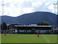
Langland Stadium
The picturesque home of Malvern Town FC.
Image: © Stuart Shepherd
Taken: 25 Apr 2009
0.08 miles
8
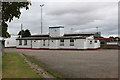
Malvern Town Football Club
The outside of the pavilion.
Image: © Bob Embleton
Taken: 8 Sep 2011
0.08 miles
9
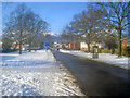
Madresfield Road
View west along a gritted Madresfield Road. In the background is the snow-covered Worcestershire Beacon. North Hill is behind the trees on the right.
Image: © Trevor Rickard
Taken: 8 Jan 2010
0.09 miles
10
Clare Road, Sherrards Green, Malvern
Part of the massive post-war boom in council house construction.
500 council houses were completed in 5 years.
From the alterations that have taken place it would appear that many of these have been sold off.
Worcestershire Beacon in the background.
Image: © Bob Embleton
Taken: 8 Sep 2011
0.09 miles