IMAGES TAKEN NEAR TO
Opal Grove, LEIGH, WN7 4JJ
Introduction
This page details the photographs taken nearby to Opal Grove, WN7 4JJ by members of the Geograph project.
The Geograph project started in 2005 with the aim of publishing, organising and preserving representative images for every square kilometre of Great Britain, Ireland and the Isle of Man.

There are currently over 7.5m images from over14,400 individuals and you can help contribute to the project by visiting https://www.geograph.org.uk
Image Map (Loading...)


Getting Data...Please wait
Leaflet Map data © OpenStreetMap
Images are licensed for reuse under creativecommons.org/licenses/by-sa/2.0
Notes
- Clicking on the map will re-center to the selected point.
- The higher the marker number, the further away the image location is from the centre of the postcode.
Image Listing (53 Images Found)
Images are licensed for reuse under creativecommons.org/licenses/by-sa/2.0
Image
Details
Distance
1
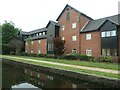
Quayside, Leigh
Housing on the south bank of the Leigh branch of the Leeds & Liverpool canal. A long and narrow site, previously a rope works. 'Wharf view' would be a more accurate name.
Image: © Christine Johnstone
Taken: 29 May 2021
0.06 miles
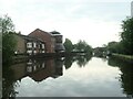
2
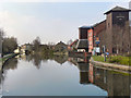
Leeds and Liverpool Canal , Leigh Branch
Looking west, along the Leigh Branch of the Leeds & Liverpool Canal from the towpath at Leigh Bridge. This branch of the canal was opened in 1820, connecting the Leeds-Liverpool Canal at Poolstock, Wigan to the Bridgewater Canal at Leigh Bridge.
Image: © David Dixon
Taken: 24 Mar 2011
0.08 miles
3
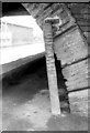
Towing pole, Leigh Bridge, King Street
Towing pole may well not be the correct name* but the grooves made by generations of ropes harnessed to generations of horses towing barges can clearly be seen.
* I have since been informed by Robert Wade that it is in fact called a Tow line roller, the purpose of which was to reduce damage to the stonework and to keep the barge-boat mid-stream on bends. Many thanks to Robert for this information.
Image: © Chris Denny
Taken: Unknown
0.08 miles
4
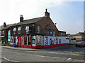
The Centurion, Leigh
The Centurion, at the corner of St Helens Road and Diamond Street in Leigh, was formerly "The Ellesmere" (see sign on the side wall). It re-opened as "The Centurion" in 2008.
Image: © David Dixon
Taken: 24 Mar 2011
0.09 miles
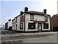
5
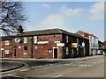
The Britannia
Public house at the corner of Etherstone Street and St Helens Road.
Image: © David Dixon
Taken: 24 Mar 2011
0.09 miles
6
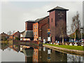
Waterside Inn, Leeds and Liverpool Canal
The Waterside Inn, on the bank of the Leigh branch of the Leeds and Liverpool Canal.
Image: © David Dixon
Taken: 24 Mar 2011
0.09 miles
7

The Waterside Inn Pub, Leigh
Canal Street LEIGH WN7 4DB on The Leeds and Liverpool Canal Leigh Branch
Image: © canalandriversidepubs co uk
Taken: 9 Apr 2010
0.09 miles
8
The former Leigh Wharf, off Canal Street
On the north bank of the Leigh branch of the Leeds & Liverpool canal. On the 1845 large-scale OS map, this wharf is at the edge of Leigh's built-up area.
Image: © Christine Johnstone
Taken: 29 May 2021
0.09 miles
9
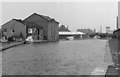
Looking east towards Leigh Bridge, 1976
Leigh Bridge is where the Bridgewater Canal (to the east) becomes the Leigh Branch of the Leeds and Liverpool Canal (seen here). The large building to the left has become the Waterside Inn. Just visible on the extreme right is the long building of Manley's Rope works.
Image: © Chris Denny
Taken: Unknown
0.10 miles
10
The Bridgewater Arms
Former public house at 33, St Helens Road, Leigh.
Image: © David Dixon
Taken: 24 Mar 2011
0.10 miles