IMAGES TAKEN NEAR TO
WD18 0XA
Introduction
This page details the photographs taken nearby to WD18 0XA by members of the Geograph project.
The Geograph project started in 2005 with the aim of publishing, organising and preserving representative images for every square kilometre of Great Britain, Ireland and the Isle of Man.

There are currently over 7.5m images from over14,400 individuals and you can help contribute to the project by visiting https://www.geograph.org.uk
Image Map
Images are licensed for reuse under creativecommons.org/licenses/by-sa/2.0
Notes
- Clicking on the map will re-center to the selected point.
- The higher the marker number, the further away the image location is from the centre of the postcode.
Image Listing (50 Images Found)
Images are licensed for reuse under creativecommons.org/licenses/by-sa/2.0
Image
Details
Distance
1
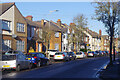
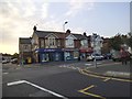
Hagden Lane, Watford
Looking along Hagden Lane from the junction with Kelmscott Crescent. This is a stretch of the A4145.
Image: © Stephen McKay
Taken: 12 Jan 2022
0.07 miles
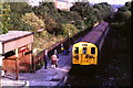
2
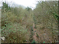
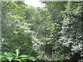
Watford West station (believe it or not!)
The line and station closed in 1996, but all seems to be intact from the little that can be seen through the vegetation. The single line third rail electrified line is still there, presumably switched off; the platform edge can just be glimpsed; more clearly seen are the lamp standards on the platform. Compare with earlier views in 2005 Image and operational in 1985 Image .
Image: © Robin Webster
Taken: 10 Mar 2013
0.08 miles
3
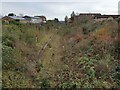
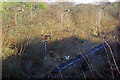
Croxley Rail Link (17): Site of the former Watford West Station
Five years on from Image] and amidst funding disputes that have caused the project to stall, vegetation is again taking over the old station site, although the track remains extant. The edge of the platform and its old lampposts in faded Network Rail red paint can still be seen.
Image: © Nigel Cox
Taken: 24 Nov 2020
0.09 miles
4
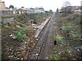
Croxley Rail Link (13): Site of the former Watford West Station
This is the former Watford West station, dating from 1912 and the opening of the L&NWR's Croxley Branch. The new Croxley Rail Link, now known as the Metropolitan Line Extension, would utilize the trackbed through here, but it is not planned to re-open the old station. The trackside vegetation has been cleared in preparation for the link and the extents of the old station can be seen from the Tolpits Lane bridge for the first time in many years. Little other than the platform, steps and lamp posts remain and the litter is a real eyesore.
This view has now been taken and submitted to Geograph in:-
September 1985 Image
April 2005 Image
March 2008 Image
March 2013 Image
August 2013 Image
Image: © Nigel Cox
Taken: 13 Dec 2015
0.09 miles
5

Watford West Station
Nature has further encroached since this 2005 view: Image although the rails are still in place, barely visible through the undergrowth.
The Croxley Green branch was opened in 1912, becoming an outpost of the DC electrified system running out of Euston and Broad Street. For much of the line's existence the service consisted of a peak hours shuttle to and from Watford Junction although in NSE days an attempt was made to increase patronage with an all-day service. This was not successful; the stations were not ideally located and the frequent bus services that passed closer to Watford's amenities were a better option for most potential customers. In the end the trains were 'temporarily' withdrawn in 1996 with a purely nominal road replacement. The trains were never reinstated and permanent withdrawal came in 2003 - a rare example of a railway closure in the post-privatisation period.
Image: © Stephen McKay
Taken: 12 Jan 2022
0.09 miles
6
Croxley Rail Link (6): Former Watford West station
In July 2013 The Secretary of State for Transport issued a Transport and Works Act Order for the proposed Croxley Rail Link scheme granting the planning permissions, access rights and land transfers necessary for the scheme to go ahead. The £118m scheme proposes that the current London Underground Metropolitan Line branch to Watford would be re-routed from a point east of Croxley station and extended to Watford Junction station via Watford High Street station, with the closure of the original Watford station to passenger traffic. It is proposed that new stations would be provided on the new rail link at Ascot Road, where a park and ride facility would be provided, and at Vicarage Road, in order to serve Watford General Hospital, the proposed Watford Health Campus development, and Watford Football Club. Construction work is scheduled to commence in 2014 with completion planned for 2016. The Croxley Rail Link's website is here http://www.croxleyraillink.com/Default.htm
This is the former Watford West station, dating from 1912 and the opening of the L&NWR's Croxley Branch. The new line would utilize the trackbed through here, but it is not planned to re-open the old station. Despite the summer vegetation it can be seen that the track and the platform of the former station are still extant. This is the view from the Tolpits Lane bridge.
This view has been taken in:-
September 1985 Image
April 2005 Image
March 2008 Image
March 2013 Image
Image: © Nigel Cox
Taken: 4 Aug 2013
0.10 miles
7
Watford West station, 1985
Watford West station was on a short branch line from Watford to Croxley Green. The line was abandoned after trains stopped running in 1996. There is a proposal to rebuild the line so that London Underground's Metropolitan Line can be diverted to Watford Junction. However, Watford West station will not reopen.
Image: © Malc McDonald
Taken: 23 Sep 1985
0.10 miles
8
Watford West Station
Watford West was the only intermediate station on the Croxley Green branch. The faded red paint on the lampposts tell us that it was once part of the Network SouthEast network. The 'H' frame at the end of the platform housed a mirror for driver only operation. See Image taken from the same viewpoint in 1985.
The Croxley Green branch was opened in 1912, becoming an outpost of the DC electrified system running out of Euston and Broad Street. For much of the line's existence the service consisted of a peak hours shuttle to and from Watford Junction although in NSE days an attempt was made to increase patronage with an all-day service. This was not successful; the stations were not ideally located and the frequent bus services that passed closer to Watford's amenities were a better option for most potential customers. In the end the trains were 'temporarily' withdrawn in 1996 with a purely nominal road replacement. The trains were never reinstated and permanent withdrawal came in 2003 - a rare example of a railway closure in the post-privatisation period. Proposals to link the route of the branch with the Metropolitan Line - allowing Metropolitan Line trains to reach Watford Junction - are, at the time of writing, very much on the back burner.
Image: © Stephen McKay
Taken: 12 Jan 2022
0.10 miles
9
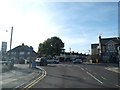
Hagden Lane at the junction of Tolpits Lane
Hagden Lane is one of the worst roads to navigate in Britain, it turns three 90 degree corners and as you can see barely a signpost to be seen. There is rarely a time in the daytime when it's not jammed in one direction or the other, as it funnels all the traffic in and out of Watford from the west not heading to Croxley.
Image: © David Howard
Taken: 6 Sep 2012
0.11 miles
10
Euston Avenue at the junction of Hagden Lane
Image: © David Howard
Taken: 18 Aug 2016
0.11 miles