IMAGES TAKEN NEAR TO
Axbridge Avenue, ST. HELENS, WA9 4NZ
Introduction
This page details the photographs taken nearby to Axbridge Avenue, WA9 4NZ by members of the Geograph project.
The Geograph project started in 2005 with the aim of publishing, organising and preserving representative images for every square kilometre of Great Britain, Ireland and the Isle of Man.

There are currently over 7.5m images from over14,400 individuals and you can help contribute to the project by visiting https://www.geograph.org.uk
Image Map
Images are licensed for reuse under creativecommons.org/licenses/by-sa/2.0
Notes
- Clicking on the map will re-center to the selected point.
- The higher the marker number, the further away the image location is from the centre of the postcode.
Image Listing (7 Images Found)
Images are licensed for reuse under creativecommons.org/licenses/by-sa/2.0
Image
Details
Distance
1
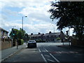
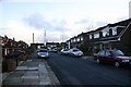
Taunton Avenue, Sutton Leach, St.Helens
A view of Taunton Avenue looking North West.
Running at the bottom of this road and across the photo is Axbridge Avenue, which leads on to a dead end.
Over and behind the houses running parallel in this photo is Leach Lane, Sutton Dam, the Wheatsheaf and Mill House pubs and to the right of the photo and behind the houses are the playing fields of Sidac Sports & Social Club, then farmers fields as far as Burtonwood and the M62 Motorway junction close to Ikea & Marks and Spencer megastores.
Image: © Alan Pennington
Taken: 9 Dec 2006
0.08 miles
2
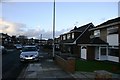
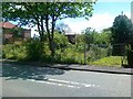
Taunton Avenue, Sutton Leach, St.Helens
A view of Taunton Avenue looking South East towards Bold & Widnes.
Out of the picture and ahead some 5 miles away, the Fiddlers Ferry Power Station and the mudflats of the River Mersey. To the left a little, and some 6 miles Warrington, far right some 12 miles Liverpool, and far left 25 miles the city of Manchester. This area is on both flight lines for Liverpool & Manchester airports, planes fly reasonably low over this neck of the woods, but to be honest they don't cause any noise problems as they are normally on a glide path to land rather than take off.
Image: © Alan Pennington
Taken: 9 Dec 2006
0.08 miles
4
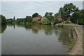
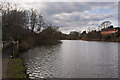
Sutton Mill Dam, St.Helens
This is Sutton Mill Dam as seen from the dam end. It's right in the middle of two housing estates near Sutton Leach, St.Helens. Not too sure about its history but I think it's safe to say that it was built to serve a local mill. I couldn't find any signs of the mill but there was a Millhouse pub nearby. A local told me that a couple of years ago there was a fire close by and toxins were washed into the dam that, at the time, was a thriving fishing venue. The dam is now on the mend I believe.
Image: © andy
Taken: 17 Jul 2005
0.15 miles