IMAGES TAKEN NEAR TO
Thames Road, LONDON, W4 3RQ
Introduction
This page details the photographs taken nearby to Thames Road, W4 3RQ by members of the Geograph project.
The Geograph project started in 2005 with the aim of publishing, organising and preserving representative images for every square kilometre of Great Britain, Ireland and the Isle of Man.

There are currently over 7.5m images from over14,400 individuals and you can help contribute to the project by visiting https://www.geograph.org.uk
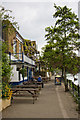
Image Map
Images are licensed for reuse under creativecommons.org/licenses/by-sa/2.0
Notes
- Clicking on the map will re-center to the selected point.
- The higher the marker number, the further away the image location is from the centre of the postcode.
Image Listing (226 Images Found)
Images are licensed for reuse under creativecommons.org/licenses/by-sa/2.0
Image
Details
Distance
1
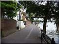
River Thames
A house on the north bank of the River Thames with flood defences in place. In the sky is an airliner heading for Heathrow Airport.
Image: © Burgess Von Thunen
Taken: 24 Jul 2010
0.02 miles
2
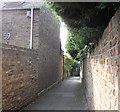
Post Office Alley
The alley runs between Thames Road and Strand on the Green.
Image: © PAUL FARMER
Taken: 19 Sep 2009
0.02 miles
3
Post Office Alley
Leading between Thames Road and the riverside walk Strand-on-the-Green, this alley got its name because it actually led to a post office, though where that building was I have been unable to ascertain. The houses at the end look as if they block the path but the one on the left, which dates to 1752, has its first floor built over the path and a low narrow tunnel at ground level allow access through the property to the riverside walk.
Image: © Martin Addison
Taken: 7 May 2010
0.02 miles
4
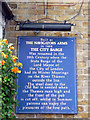
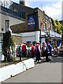
Information Board, City Barge, Kew
Originally built as the Navigators Inn, this public house was re-named The City Barge in the 19th century when the state barge of the Lord Mayor of the City of London was moored outside the inn in the winter. The metal door of the Old Bar is needed when the Thames floods.
Image: © Christine Matthews
Taken: 11 May 2011
0.02 miles
5
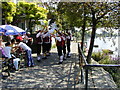
Towpath, North Bank of the River Thames, Kew
Looking east towards the railway bridge from the City Barge.
Image: © Christine Matthews
Taken: 11 May 2011
0.02 miles
6
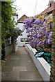
Strand on the Green
Strand on the Green is a narrow picturesque walkway on the river, running east from Kew Bridge, with varied vintage houses and pubs along its length.
Image: © Chris Gunns
Taken: 20 Jul 2002
0.03 miles
7
Strand on the Green
Strand on the Green is a narrow picturesque walkway on the river, running east from Kew Bridge, with varied vintage houses and pubs along its length.
Image: © Chris Gunns
Taken: 20 Jul 2002
0.03 miles
8
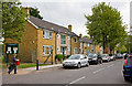
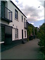
Housing on Thames Road
Post-war housing on Thames Road. The board on the right refers to Strand-on-the-Green Recreation Ground which is located behind these dwellings.
Image: © Martin Addison
Taken: 7 May 2010
0.03 miles
9
The City Barge
Located on Strand-on-the-Green this pub resembles a much older building inside than its frontage suggests. In fact, it was badly damaged by a land mine during world war II and was rebuilt taking over the two adjacent plots to the southeast where there had been two Elizabethan houses that were destroyed by the same land mine. The pub provides pleasant riverside views for those sitting outside in the summer although it was a bit chilly on the day that I visited.
Image: © Martin Addison
Taken: 7 May 2010
0.03 miles
10
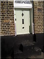
Small door at Strand-on-the-Green
When this house along the riverside at Strand-on-the-Green was built, this door would have been at its full height of six and a half to seven feet. When the steps at the front were added as a form of flood defence, the door was not raised so that it is now only about four feet high.
Image: © Marathon
Taken: 8 Oct 2010
0.04 miles