IMAGES TAKEN NEAR TO
Kingdom Street, LONDON, W2 6JP
Introduction
This page details the photographs taken nearby to Kingdom Street, W2 6JP by members of the Geograph project.
The Geograph project started in 2005 with the aim of publishing, organising and preserving representative images for every square kilometre of Great Britain, Ireland and the Isle of Man.

There are currently over 7.5m images from over14,400 individuals and you can help contribute to the project by visiting https://www.geograph.org.uk
Image Map
Images are licensed for reuse under creativecommons.org/licenses/by-sa/2.0
Notes
- Clicking on the map will re-center to the selected point.
- The higher the marker number, the further away the image location is from the centre of the postcode.
Image Listing (822 Images Found)
Images are licensed for reuse under creativecommons.org/licenses/by-sa/2.0
Image
Details
Distance
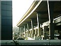
2
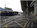
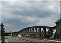
Slip road and roundabout for Paddington Central
The roads here are in three layers. Top is the Westway, A40 elevated carriageway. Middle is the Harrow Road A404 Westbound. Bottom are service roads of Paddington Central and Paddington Basin. This photo taken from under Westway by the Battleship Building show the slip road up from a roundabout at bottom level to the middle level.
Image: © David Hawgood
Taken: 17 Sep 2011
0.04 miles
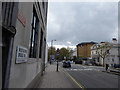
3
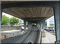
Harrow Road and Westway
The Westway is above. Although disruptive when built in the 1960s small plots of unused land under and around it have been put to all manner of ingenious uses (not really in this spot though).
To the right of the trees, this building can be glimpsed: Image
Image: © Stephen Richards
Taken: 3 Jul 2011
0.05 miles
4
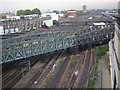
Paddington approach
Lines approaching Paddington Station, seen from the Novotel on Kingdom Street W2
Image: © Richard Croft
Taken: 14 Oct 2009
0.05 miles
5
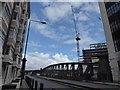
Westway & Harrow Road, W2
One of the few places in Britain where you get double tier roads, above is Westway the former A40(M), below Harrow Road the A404.
Image: © Phillip Perry
Taken: 5 Feb 2007
0.05 miles
6
Slow, slow, quick, quick, slower (80)
Pedestrians on Westbourne Bridge
Image: © Basher Eyre
Taken: 23 Apr 2016
0.05 miles
7
Slow, slow, quick, quick, slower (81)
Looking south-east at Westbourne Bridge
Image: © Basher Eyre
Taken: 23 Apr 2016
0.05 miles
8
Slow, slow, quick, quick, slower (82)
Mid section of Westbourne Bridge
Image: © Basher Eyre
Taken: 23 Apr 2016
0.05 miles
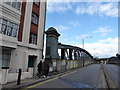
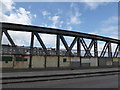
9
Westbourne Bridge, Westbourne Terrace
Built after 1909 by the Great Western Railway. A steel girder bridge of "bow string shape of 2 long spans with central piers. Centre and ends with finialed decorative standards." Grade II listed.
Image: © Stephen Richards
Taken: 3 Jul 2011
0.06 miles
10
Slow, slow, quick, quick, slower (79)
Approaching Westbourne Bridge
Image: © Basher Eyre
Taken: 23 Apr 2016
0.06 miles