IMAGES TAKEN NEAR TO
Lyncroft Gardens, LONDON, W13 9PX
Introduction
This page details the photographs taken nearby to Lyncroft Gardens, W13 9PX by members of the Geograph project.
The Geograph project started in 2005 with the aim of publishing, organising and preserving representative images for every square kilometre of Great Britain, Ireland and the Isle of Man.

There are currently over 7.5m images from over14,400 individuals and you can help contribute to the project by visiting https://www.geograph.org.uk
Image Map
Images are licensed for reuse under creativecommons.org/licenses/by-sa/2.0
Notes
- Clicking on the map will re-center to the selected point.
- The higher the marker number, the further away the image location is from the centre of the postcode.
Image Listing (54 Images Found)
Images are licensed for reuse under creativecommons.org/licenses/by-sa/2.0
Image
Details
Distance
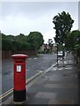
1
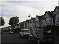
Junction of Lyncroft Road and Lavington Road, Ealing, W13
Upmarket Edwardian suburbia in Ealing.
Image: © Peter Jordan
Taken: 9 Sep 2006
0.07 miles
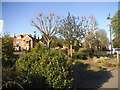
2
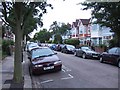
Lancaster Gardens, Ealing
One of many tree-lined residential roads in western Ealing
Image: © David Smith
Taken: 14 Jun 2011
0.10 miles
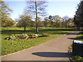
3
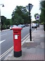
Elers Road
A Victorian pillarbox at the north end of Elers Road. On the left is Lammas Park
Image: © David Smith
Taken: 14 Jun 2011
0.12 miles
4
Churchfield Road, Ealing
The pillarbox is dated Edward VII. The area was developed for housing at the end of the 19th century, so the postal infrastructure dates from that period
Image: © David Smith
Taken: 16 Jun 2011
0.13 miles
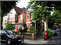
5
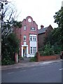
House in Elers Road
The house is dated 1898, and shows Dutch influence in the gable.
Image: © David Smith
Taken: 14 Jun 2011
0.13 miles
9
![Ealing houses [10]](https://s3.geograph.org.uk/geophotos/06/36/79/6367919_d4766576_120x120.jpg)
Ealing houses [10]
Number 20 Culmington Road is a finely detailed detached house one of a series of similar properties.
Ealing is one of the seven major towns in the London Borough of Ealing. A rural village until communications with London got better with the improvements to the road to Oxford (later Uxbridge Road) in the 18th century and culminating with the coming of the railway in 1838. Ealing expanded greatly with suburban development during the 19th century and became known as the "Queen of the Suburbs" due to its greenery and because it was halfway between city and country. Ealing became a municipal borough in 1901. Growth continued throughout the 20th century and Ealing became part of a modern London borough in 1965.
Image: © Michael Dibb
Taken: 14 Sep 2019
0.15 miles