IMAGES TAKEN NEAR TO
Russell Gardens, WEST DRAYTON, UB7 0LR
Introduction
This page details the photographs taken nearby to Russell Gardens, UB7 0LR by members of the Geograph project.
The Geograph project started in 2005 with the aim of publishing, organising and preserving representative images for every square kilometre of Great Britain, Ireland and the Isle of Man.

There are currently over 7.5m images from over14,400 individuals and you can help contribute to the project by visiting https://www.geograph.org.uk
Image Map
Images are licensed for reuse under creativecommons.org/licenses/by-sa/2.0
Notes
- Clicking on the map will re-center to the selected point.
- The higher the marker number, the further away the image location is from the centre of the postcode.
Image Listing (53 Images Found)
Images are licensed for reuse under creativecommons.org/licenses/by-sa/2.0
Image
Details
Distance
1
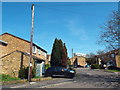
Russell Gardens, Sipson
Russell Gardens is a small housing development in the village of Sipson, close to London's Heathrow Airport.
Image: © Malc McDonald
Taken: 18 Apr 2018
0.02 miles
2
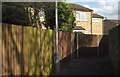
Path, Russell Gardens, Sipson
The footpath links the A408 to the northern end of the cul-de-sac shown in Image
Image: © Derek Harper
Taken: 26 Apr 2018
0.03 miles
4
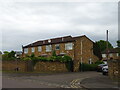
Russell Gardens, Sipson
Taken a few days after Image, and looking across Sipson Road into the cul-de-sac.
Image: © Derek Harper
Taken: 26 Apr 2018
0.03 miles
5
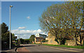
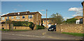
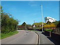
Sipson Road
The A408 heading northwards through housing, with a Holiday Inn visible down the road.
Image: © Derek Harper
Taken: 26 Apr 2018
0.03 miles
6
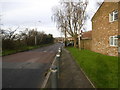
Sipson Road
This is towards the northern end of Sipson. The Plough public house is just around the corner with the M4 beyond that.
Image: © Marathon
Taken: 13 Jan 2016
0.03 miles
7
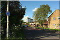
Sipson Road
The A408 passing the northernmost housing in the village, on the right of the road, with the Holiday Inn looming large ahead, 300 metres from the camera. The number 89 cycle route sign refers to the London Cycle Network, which seems to lead from Heathrow to New Soutgtae.
Image: © Derek Harper
Taken: 26 Apr 2018
0.05 miles
9
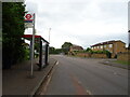
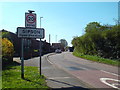
Sipson Road, Sipson
A view northwards along Sipson Road, heading out of the village of Sipson.
A Holiday Inn hotel looms in the background. This is one of several hotels in the area catering to travellers flying from and to Heathrow Airport, which is close by.
Image: © Malc McDonald
Taken: 18 Apr 2018
0.08 miles
10
Sipson Road, Sipson
A view of Sipson Road entering the village of Sipson, near London's Heathrow Airport.
Image: © Malc McDonald
Taken: 18 Apr 2018
0.08 miles