IMAGES TAKEN NEAR TO
Wykeham Close, WEST DRAYTON, UB7 0LH
Introduction
This page details the photographs taken nearby to Wykeham Close, UB7 0LH by members of the Geograph project.
The Geograph project started in 2005 with the aim of publishing, organising and preserving representative images for every square kilometre of Great Britain, Ireland and the Isle of Man.

There are currently over 7.5m images from over14,400 individuals and you can help contribute to the project by visiting https://www.geograph.org.uk
Image Map
Images are licensed for reuse under creativecommons.org/licenses/by-sa/2.0
Notes
- Clicking on the map will re-center to the selected point.
- The higher the marker number, the further away the image location is from the centre of the postcode.
Image Listing (45 Images Found)
Images are licensed for reuse under creativecommons.org/licenses/by-sa/2.0
Image
Details
Distance
1
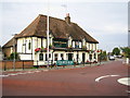
Sipson: King William IV pub
This pub is at the junction of the A408 Sipson Road with Harmondsworth Lane. However Sipson's 700 homes, shops, pubs, small businesses and school will be buried under taxiways, terminals, concourses and car parks by 2020 if this year's government review of its 2003 Aviation White Paper approves a Third Runway at Heathrow Airport. The No Third Runway Action Group website is here http://www.notrag.org/index.php
Image: © Nigel Cox
Taken: 2 Sep 2006
0.03 miles
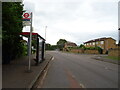
2
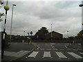
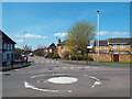
Roundabout at the end of Harmondsworth Lane, Sipson
Image: © David Howard
Taken: 21 Oct 2013
0.04 miles
3
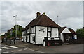
King William IV, West Drayton
On Sipson Road.
Image: © JThomas
Taken: 23 May 2022
0.04 miles
4
Harmondsworth Lane, Sipson
Approaching the mini-roundabout at the junction with the A408 Sipson Road, with the King William pub ("Late medieval. Formerly a hall house" https://www.historicengland.org.uk/listing/the-list/list-entry/1080164 ) in the centre - see also http://www.geograph.org.uk/search.php?i=84258970 .
Image: © Derek Harper
Taken: 26 Apr 2018
0.04 miles
5
Mini-roundabout in Sipson
A mini-roundabout at the junction of Sipson Road and Harmondsworth Lane, in the village of Sipson in outer west London.
Image: © Malc McDonald
Taken: 18 Apr 2018
0.04 miles
6
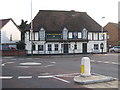
The King William IV public house
A late mediaeval building, formerly a hall house, Grade II listed. Together with all of Sipson village this is due to be demolished if the construction of Heathrow's third runway goes ahead. There is a very strong movement against the runway development and a one acre field behind the pub has been purchased by protesters with a view to selling it off as 4000 individual plots in order to frustrate the compulsory purchase procedure.
Image: © Rod Allday
Taken: 5 Mar 2010
0.04 miles
7
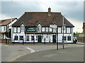
The King William, Sipson
On the corner of Harmondsworth Lane and Sipson Road.
Image: © Robin Webster
Taken: 22 Apr 2018
0.04 miles
8
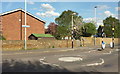
Mini-roundabout, Sipson
At the junction of the A408 with Harmondsworth Lane. he housess are on Vneries Close. The blue cycle route sign indicates London Cycle Network route 89, which ends a mile and a half away at Heathrow.
Image: © Derek Harper
Taken: 26 Apr 2018
0.05 miles
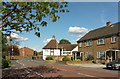
10
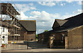
Lanz Farm, Sipson
The farmhouse on the left is listed https://www.historicengland.org.uk/listing/the-list/list-entry/1080219 . The barns are being converted into four dwellings https://modgov.hillingdon.gov.uk/documents/s29406/Lanz%20Farm%2033%20Harmondsworth%20Lane%20-%20Final%20Report%201576.pdf .
Image: © Derek Harper
Taken: 26 Apr 2018
0.07 miles