IMAGES TAKEN NEAR TO
Lynhurst Crescent, UXBRIDGE, UB10 9EQ
Introduction
This page details the photographs taken nearby to Lynhurst Crescent, UB10 9EQ by members of the Geograph project.
The Geograph project started in 2005 with the aim of publishing, organising and preserving representative images for every square kilometre of Great Britain, Ireland and the Isle of Man.

There are currently over 7.5m images from over14,400 individuals and you can help contribute to the project by visiting https://www.geograph.org.uk
Image Map
Images are licensed for reuse under creativecommons.org/licenses/by-sa/2.0
Notes
- Clicking on the map will re-center to the selected point.
- The higher the marker number, the further away the image location is from the centre of the postcode.
Image Listing (18 Images Found)
Images are licensed for reuse under creativecommons.org/licenses/by-sa/2.0
Image
Details
Distance
1
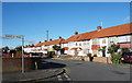
Lynhurst Crescent
Junction with Berkeley Road.
Image: © Des Blenkinsopp
Taken: 28 Nov 2017
0.07 miles
4
Yeading Brook
The Brook is quite well hidden with this being a visible part.
Part of the Hillingdon Trail.
Image: © James Emmans
Taken: 25 Jul 2019
0.10 miles
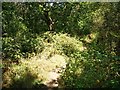
5
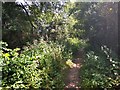
Footpath next to Yeading Brook
River info - https://en.wikipedia.org/wiki/Yeading_Brook
Image: © James Emmans
Taken: 25 Jul 2019
0.10 miles
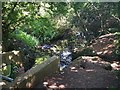
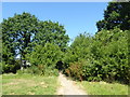
7
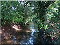
The Yeading Brook in Cutthroat Wood
The Yeading Brook is around 26kms long and forms the upper part of the River Crane catchment.
The catchment drains 125 square kilometres of suburban West London before joining the tidal Thames at Isleworth. http://www.cranevalley.org.uk/catchment/catchment-information.html
The Hillingdon Trail runs alongside this section.
Image: © Des Blenkinsopp
Taken: 9 Oct 2014
0.13 miles
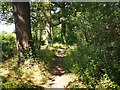
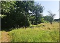
9
The Hillingdon Trail approaching Gutteridge Wood
The Hillingdon Trail is a 20 mile path through Hillingdon's countryside from Cranford in the south-east to Harefield in the north-west. Here it is about to enter Gutteridge Wood.
Gutteridge Wood in Hillingdon is an area of traditional countryside character, including ancient woodland and wildflower meadows. It is part of the Yeading Brook Valley. The woodland is ancient which means it dates from at least the 17th century. It was once called Great Ditch Wood. It is owned by the London Borough of Hillingdon and is now managed by the London Wildlife Trust. Full details can be found at https://www.wildlondon.org.uk/reserves/gutteridge-wood
Image: © Marathon
Taken: 27 Jun 2018
0.19 miles
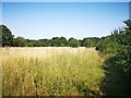
10
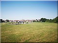
Recreation Ground
Exercise area with Houses in background in Windsor Avenue.
Image: © James Emmans
Taken: 25 Jul 2019
0.20 miles