IMAGES TAKEN NEAR TO
Wallasey Crescent, UXBRIDGE, UB10 8SA
Introduction
This page details the photographs taken nearby to Wallasey Crescent, UB10 8SA by members of the Geograph project.
The Geograph project started in 2005 with the aim of publishing, organising and preserving representative images for every square kilometre of Great Britain, Ireland and the Isle of Man.

There are currently over 7.5m images from over14,400 individuals and you can help contribute to the project by visiting https://www.geograph.org.uk
Image Map
Images are licensed for reuse under creativecommons.org/licenses/by-sa/2.0
Notes
- Clicking on the map will re-center to the selected point.
- The higher the marker number, the further away the image location is from the centre of the postcode.
Image Listing (11 Images Found)
Images are licensed for reuse under creativecommons.org/licenses/by-sa/2.0
Image
Details
Distance
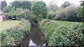
1
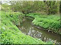
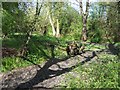
River Pinn
A section of the River Pinn in Ickenham
Image: © Ian Harrison
Taken: 11 Apr 2011
0.07 miles
2
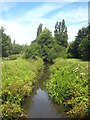
The River Pinn at Ickenham
Viewed from the bridge in Swakeleys Road. The Pinn rises in what is now Ruislip Lido and joins the River Colne at Uxbridge.
Image: © Rod Allday
Taken: 30 Jun 2013
0.09 miles
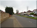
3
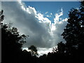
Changing cloud formations on the Celandine Route at Ickenham
Image: © Peter S
Taken: 22 Oct 2020
0.09 miles
4
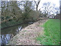
River Pinn. looking towards Swakeleys Road, Ickenham
Image: © Pip Rolls
Taken: 20 Jan 2005
0.12 miles
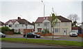
6
Swakeleys Road, Ickenham
Looking west on the B467.
Image: © JThomas
Taken: 13 Apr 2019
0.12 miles
7
River Pinn
River Pinn by Copthall Road West
Image: © Shaun Ferguson
Taken: 17 May 2019
0.15 miles
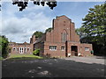
8
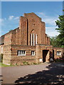
Ickenham United Reformed Church, Swakeleys Road
This church opened in 1936
Image: © David Hawgood
Taken: 19 Jun 2005
0.20 miles
9
Pynchester Moat
Part of the Pynchester Moat, a Scheduled Ancient Monument on the River Pinn just east of Copthall Road West. Although usually dry in the summer months, the moat surrounding the location of a manor house can still be seen.
Image: © Ian Harrison
Taken: 10 Apr 2011
0.20 miles
10
Ickenham URC: mid August 2016
Which is in partnership with the Anglican church St Giles http://www.geograph.org.uk/photo/3548789
Image: © Basher Eyre
Taken: 13 Aug 2016
0.21 miles