IMAGES TAKEN NEAR TO
Selwyn Avenue, RICHMOND, TW9 2HB
Introduction
This page details the photographs taken nearby to Selwyn Avenue, TW9 2HB by members of the Geograph project.
The Geograph project started in 2005 with the aim of publishing, organising and preserving representative images for every square kilometre of Great Britain, Ireland and the Isle of Man.

There are currently over 7.5m images from over14,400 individuals and you can help contribute to the project by visiting https://www.geograph.org.uk
Image Map
Images are licensed for reuse under creativecommons.org/licenses/by-sa/2.0
Notes
- Clicking on the map will re-center to the selected point.
- The higher the marker number, the further away the image location is from the centre of the postcode.
Image Listing (108 Images Found)
Images are licensed for reuse under creativecommons.org/licenses/by-sa/2.0
Image
Details
Distance
2
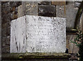
Christ Church, Kew Road - Foundation stone
Image: © John Salmon
Taken: 28 Nov 2012
0.03 miles
4
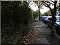
Pedestrian's eye view of Selwyn Avenue, Richmond
Modern policies create new trip hazards.
Image: © David Howard
Taken: 5 Nov 2013
0.03 miles
5
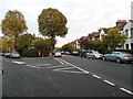
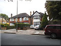
The junction between Selwyn Avenue and Belmont Avenue
Image: © David Howard
Taken: 5 Nov 2013
0.03 miles
6
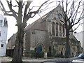
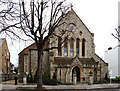
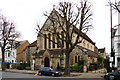
Christ Church Flats, Kew Road
Christ Church (Anglican) was closed in 1986 and converted to flats.
Image: © Stephen Craven
Taken: 15 Mar 2006
0.03 miles
8
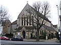
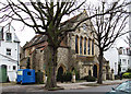
Former church
This former Anglican church was built 1862-4, closed in 1986 and was converted into residential apartments.
Image: © Michael Dibb
Taken: 26 Jan 2017
0.05 miles