IMAGES TAKEN NEAR TO
Clayponds Lane, BRENTFORD, TW8 0GW
Introduction
This page details the photographs taken nearby to Clayponds Lane, TW8 0GW by members of the Geograph project.
The Geograph project started in 2005 with the aim of publishing, organising and preserving representative images for every square kilometre of Great Britain, Ireland and the Isle of Man.

There are currently over 7.5m images from over14,400 individuals and you can help contribute to the project by visiting https://www.geograph.org.uk
Image Map
Images are licensed for reuse under creativecommons.org/licenses/by-sa/2.0
Notes
- Clicking on the map will re-center to the selected point.
- The higher the marker number, the further away the image location is from the centre of the postcode.
Image Listing (151 Images Found)
Images are licensed for reuse under creativecommons.org/licenses/by-sa/2.0
Image
Details
Distance
1
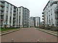
New housing estate, Clayponds Lane, Brentford
Image: © Ruth Sharville
Taken: 22 Feb 2011
0.02 miles
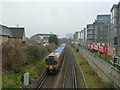
2
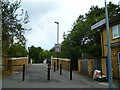
Clayponds Lane
This looks north to where the lane crosses the railway.
Image: © Shazz
Taken: 18 Sep 2013
0.02 miles
3
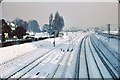
Old Goods Yard.
Taken in the Winter of 1961, this view of Brentford Goods yard was from a footbridge behind the factories of the Great West Road. The tracks on the right are the Southern Region electrified lines, whilst the remainder are tracks into the yard and beyond to Old Kew Junction and the goods line via Acton to eventually join the North London Line at Willesden. Brentford yards no longer exist but freight trains still use Old Kew Junction.
Image: © Clive Warneford
Taken: Unknown
0.03 miles
4
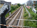
Signal gantry next to Clayponds Lane bridge
The Hounslow Loop was opened in 1849. This view looks from Clayponds Lane bridge past the gantry holding the up signal in the direction of Brentford station.
Image: © Marathon
Taken: 20 Jul 2011
0.03 miles
5
Barratt building, formerly Wallis House, Great West Road, Brentford
See Wikipedia article about the "Golden Mile" of 1930s buildings.
http://en.wikipedia.org/wiki/Golden_Mile_(Brentford)
Image: © Ruth Sharville
Taken: 22 Feb 2011
0.03 miles
6
Railway from the bridge, Clayponds Lane, Brentford
Image: © Ruth Sharville
Taken: 22 Feb 2011
0.03 miles
7
The Hounslow Loop from Clayponds Lane bridge
The Hounslow Loop was opened in 1849. This view looks from Clayponds Lane bridge in the direction of Brentford station.
Image: © Marathon
Taken: 20 Jul 2011
0.06 miles
8

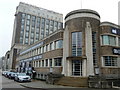
The Barratt Building
This was originally the Wallis Building named after architect, Thomas Wallis; built 1936-1942 for Simmonds Aerocessories Ltd, and then BOAC in 1947 before becoming Beechams in 1954 after BOAC moved to Heathrow. It's now a mixed use of offices and apartments.
Image: © Anthony Parkes
Taken: 15 Sep 2024
0.07 miles
9
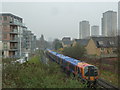
Train heading for Kew Bridge Station
Image: © Ruth Sharville
Taken: 22 Feb 2011
0.07 miles
10
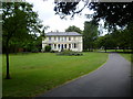
In Carville Hall Park
Carville Hall is a 19th century house, located in Carville Hall Park. The park lies between the Hounslow Loop railway to the south, and the Great West Road and M4 flyover to the north. It is easily missed and probably only local people know it is there.
Image: © Marathon
Taken: 20 Jul 2011
0.07 miles