IMAGES TAKEN NEAR TO
Ferry Lane, STAINES-UPON-THAMES, TW19 6HG
Introduction
This page details the photographs taken nearby to Ferry Lane, TW19 6HG by members of the Geograph project.
The Geograph project started in 2005 with the aim of publishing, organising and preserving representative images for every square kilometre of Great Britain, Ireland and the Isle of Man.

There are currently over 7.5m images from over14,400 individuals and you can help contribute to the project by visiting https://www.geograph.org.uk
Image Map
Images are licensed for reuse under creativecommons.org/licenses/by-sa/2.0
Notes
- Clicking on the map will re-center to the selected point.
- The higher the marker number, the further away the image location is from the centre of the postcode.
Image Listing (79 Images Found)
Images are licensed for reuse under creativecommons.org/licenses/by-sa/2.0
Image
Details
Distance
1
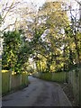
Ferry Lane, Hythe End
There is a rather uncomfortable mixture of land-uses hereabouts - Ferry Lane gives access to recent gated residential developments, but runs past what seem to be run-down industrial sites.
Image: © Stefan Czapski
Taken: 19 Feb 2012
0.06 miles
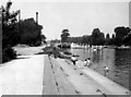
2
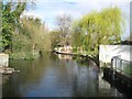
Colne Brook at Hythe End
Colne Brook is a bifurcation of the main River Colne that flows directly into the River Thames, about 500 metres downstream of here, and is about as wide and deep as the main river. This is the view looking upstream at Hythe End with the southern tip of the wooded Dearsley Island on the left. This was once the site of the Hythe End paper mill.
Image: © Nigel Cox
Taken: 23 Mar 2014
0.10 miles
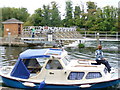
3
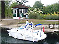
Boat in Bell Weir Lock
Small boat and small lock-keeper's hut at the weir by Egham. The lock has well kept grounds around it, like many along this stretch of the Thames.
http://www.egham.co.uk/
Image: © Colin Smith
Taken: 20 Sep 2009
0.14 miles
4
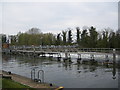
Bell Weir
The Thames runs from left to right. The river on the far side runs down the weir whilst the calmer water on the near side heads for the lock.
Image: © Ray Stanton
Taken: 9 Apr 2007
0.15 miles
5
Bell Weir Lock, River Thames
This view taken looking upstream towards the lock. The local children enjoy paddling on the steps below the lock on a warm day in May, 1974.
Image: © Dr Neil Clifton
Taken: 26 May 1974
0.15 miles
6
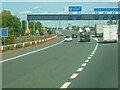
M25 Junc 13
On the clockwise side after just passing over the River Thames
Image: © David Bagshaw
Taken: 29 Jan 2006
0.16 miles
7
A30 and M25 near Hythe End
The A30 runs either side of the M25 bewtween Runnymede Roundabout and Runnymede Junction (M25 Junction 3). A total width of approximately 70 metres!
Image: © David Dixon
Taken: 11 Apr 2015
0.16 miles
8
Weir by Bell Weir Lock
Small craft passing the weir and fish ladder on the Thames by Egham.
http://www.egham.co.uk/
Image: © Colin Smith
Taken: 20 Sep 2009
0.16 miles
9
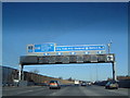
Hythe End : M25 Motorway
Looking at Junction 13 (Runnymeade)
Image: © Lewis Clarke
Taken: 12 Sep 2020
0.16 miles
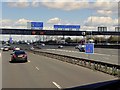
10
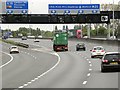
M25, Runnymede Junction
Sign and signal gantry at Junction 13 (Runnymede Junction) of the M25.
Image: © David Dixon
Taken: 17 May 2013
0.16 miles