IMAGES TAKEN NEAR TO
Victoria Road, STAINES-UPON-THAMES, TW18 4YR
Introduction
This page details the photographs taken nearby to Victoria Road, TW18 4YR by members of the Geograph project.
The Geograph project started in 2005 with the aim of publishing, organising and preserving representative images for every square kilometre of Great Britain, Ireland and the Isle of Man.

There are currently over 7.5m images from over14,400 individuals and you can help contribute to the project by visiting https://www.geograph.org.uk
Image Map
Images are licensed for reuse under creativecommons.org/licenses/by-sa/2.0
Notes
- Clicking on the map will re-center to the selected point.
- The higher the marker number, the further away the image location is from the centre of the postcode.
Image Listing (186 Images Found)
Images are licensed for reuse under creativecommons.org/licenses/by-sa/2.0
Image
Details
Distance
1
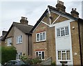
Great Western Cottages
Great Western Cottages on Moor Lane at Staines was home of Christine Keeler. According to The Telegraph, an article dated 8th November 2007 claims, “Christine Keeler used to entertain John Profumo in a disused railway carriage near here”. The affair between the two would eventually bring down Harold Macmillan's Conservative government. You can read more about "The Profumo Affair" at https://en.wikipedia.org/wiki/Profumo_affair
Image: © Sean Davis
Taken: 24 Aug 2012
0.04 miles
2
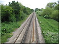
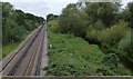
Staines: Windsor branch line railway
The railway was opened here, from Staines to Datchet, in 1848, finally reaching Windsor in 1849, after a little local, but well-heeled, opposition. Third rail electrification came in 1930. If currently planned proposals succeed this trackwork would also form part of the AirTrack railway linking Heathrow Terminal 5 with Staines and main line railway routes to the south-west. This is the view looking towards Staines, taken from the Church Lammas bridge which has always allowed commoners to access Staines Moor. For a view in the opposite direction towards Datchet and Windsor please see Image
Image: © Nigel Cox
Taken: 20 Jun 2010
0.06 miles
4
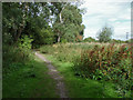
Path to the moor
The footpath that runs from the back of the Waters Drive recreation ground towards Staines Moor.
Image: © Alan Hunt
Taken: 13 Aug 2013
0.09 miles
5
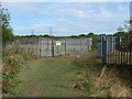
Footpath to Staines Moor
The bridge over the Staines reservoir aqueduct protected by heavy metal fencing. The A30 underpass can be seen in the background.
Image: © Alan Hunt
Taken: 13 Aug 2013
0.10 miles
6
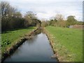
Staines Reservoirs Aqueduct (2)
The aqueduct was completed around 1900 to take water from the River Thames, about 300 metres upstream of Bell Weir Lock in Image, about 3 kilometres downstream to the two new Staines Reservoirs. Sections of the aqueduct are in tunnels with siphons and some reaches such as this are open. This is the view from a public footpath bridge crossing.
Image: © Nigel Cox
Taken: 23 Mar 2014
0.10 miles
7
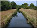
Staines reservoir aqueduct
The aqueduct that runs from the Thames intake at Hythe End to the pumping station near the Crooked Billet roundabout where the water is pumped to the George VI and Staines storage reservoirs. The aqueduct dates from 1910.
Image: © Alan Hunt
Taken: 13 Aug 2013
0.10 miles
8
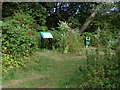
Information board
The information board by the entrance to the footpath to Staines Moor at the rear of the Waters Drive recreation ground.
Image: © Alan Hunt
Taken: 13 Aug 2013
0.11 miles
9
Railway & Wraysbury River from Old Cattle Bridge
Train on its way from Staines to Windsor & Eton Riverside, taken from the “Cattle Bridge” or "Drover’s Bridge". To the right is the Wraysbury River and hidden by the trees is the now closed Great Western Railway and next to it is Staines Aqueduct. It sounds complicated but the Cattle Bridge consists of three different bridges built between c1840 and 1885. It provides access from Moor Lane to Staines Moor.
Image: © Sean Davis
Taken: 24 Aug 2012
0.11 miles
10
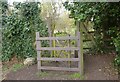
Kissing Gate from Moormede to Staines Moor
This wooden kissing gate is the entrance to Staines Moor from Moormede Recreation Ground. This is on the route of The Freedom Trail long-distance path.
Image: © Sean Davis
Taken: 19 Apr 2013
0.12 miles