IMAGES TAKEN NEAR TO
Shakespeare Avenue, FELTHAM, TW14 9HX
Introduction
This page details the photographs taken nearby to Shakespeare Avenue, TW14 9HX by members of the Geograph project.
The Geograph project started in 2005 with the aim of publishing, organising and preserving representative images for every square kilometre of Great Britain, Ireland and the Isle of Man.

There are currently over 7.5m images from over14,400 individuals and you can help contribute to the project by visiting https://www.geograph.org.uk
Image Map
Images are licensed for reuse under creativecommons.org/licenses/by-sa/2.0
Notes
- Clicking on the map will re-center to the selected point.
- The higher the marker number, the further away the image location is from the centre of the postcode.
Image Listing (13 Images Found)
Images are licensed for reuse under creativecommons.org/licenses/by-sa/2.0
Image
Details
Distance
1
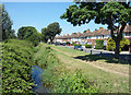
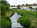
The Longford River at Ruskin Avenue
The Longford River is a man made watercourse constructed in 1638/9 to supply clean water to Hampton Court Palace. Extensive history on https://en.wikipedia.org/wiki/Longford_River
It is looking very overgrown and neglected along here.
Image: © Des Blenkinsopp
Taken: 5 Jul 2017
0.08 miles
2
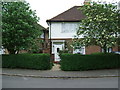
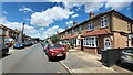
Residential Property on the "Poet's Estate" in North Feltham.
Residential Property on the "Poet's Estate" in North Feltham
Image: © Graham Newell
Taken: 9 May 2007
0.08 miles
3
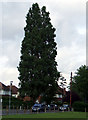
Ancient Lombardy Poplar Tree.
Ancient Poplar tree.
Image: © Graham Newell
Taken: 30 Apr 2007
0.12 miles
5
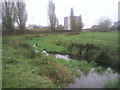
Longford River, looking upstream
The Longford River is a 17th century artificial cut to supply Hampton Court with water from the River Crane.
Image: © Robin Webster
Taken: 12 Aug 2017
0.16 miles
7
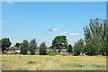
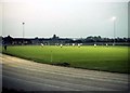
The Longford River near Feltham
The Longford River was constructed in 1638 to take water from the River Colne. This would then supplement the water supply to Hampton Court and enable the development of the water features in the park. Here it flows between Bedfont Lane Recreation Ground on the right and Glebelands Playing Fields on the left.
Image: © Marathon
Taken: 17 Nov 2010
0.19 miles
8
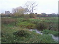
The Longford River at Bedfont Lane Recreation Ground
The Longford River was constructed in 1638 to take water from the River Colne. This would then supplement the water supply to Hampton Court and enable the development of the water features in the park. This view looks across the river from Glebelands Playing Fields to Bedfont Recreation Ground.
Image: © Marathon
Taken: 17 Nov 2010
0.19 miles
9
Feltham- Gladstone Avenue
Freddie Mercury's first London family home. The blue plaque of number 22 is the second terrace house in a line from 20 to 26.
https://en.wikipedia.org/wiki/Freddie_Mercury
Image: © James Emmans
Taken: 11 Jun 2022
0.22 miles
10
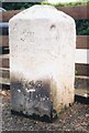
Old Milestone by the A315, Staines Road; North Feltham
Old Hounslow limestone square by the A315, in parish of Feltham (Hounslow District), Staines Road, North Feltham, opposite No. 164, in front of garage, East of Shaftesbury Avenue, behind footpath, against garage fence.
Inscription reads:-
XII
Miles from
Hyde Park
Corner
1743
Grade II listed.
List Entry Number: 1360961 https://historicengland.org.uk/listing/the-list/list-entry/1360961
Surveyed
Milestone Society National ID: MX_le12
Image: © Milestone Society
Taken: Unknown
0.22 miles