IMAGES TAKEN NEAR TO
River Gardens, FELTHAM, TW14 0RD
Introduction
This page details the photographs taken nearby to River Gardens, TW14 0RD by members of the Geograph project.
The Geograph project started in 2005 with the aim of publishing, organising and preserving representative images for every square kilometre of Great Britain, Ireland and the Isle of Man.

There are currently over 7.5m images from over14,400 individuals and you can help contribute to the project by visiting https://www.geograph.org.uk
Image Map
Images are licensed for reuse under creativecommons.org/licenses/by-sa/2.0
Notes
- Clicking on the map will re-center to the selected point.
- The higher the marker number, the further away the image location is from the centre of the postcode.
Image Listing (43 Images Found)
Images are licensed for reuse under creativecommons.org/licenses/by-sa/2.0
Image
Details
Distance
1
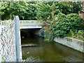
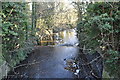
Bridge over Duke of Northumberland's River
River Gardens crosses.
Image: © Robin Webster
Taken: 14 Sep 2012
0.06 miles
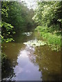
2
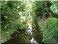
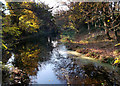
Duke of Northumberland's River
Looking downstream from the River Gardens bridge. This is shortly before it joins the River Crane.
Image: © Robin Webster
Taken: 14 Sep 2012
0.07 miles
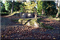
3
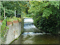
River Gardens Weir
On the upper part of the Duke of Northumberland's River, which discharges into the River Crane. The Environment Agency plate on the compound gives their reference as 36DH0101/WE01, and the NG reference as TQ1092374605. This great precision seems to accurately refer to a point somewhere in the middle of the weir.
Image: © Robin Webster
Taken: 14 Sep 2012
0.07 miles
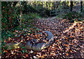
4
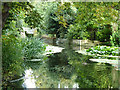
Duke of Northumberland's River
This is just upstream of River Gardens Weir.
Image: © Robin Webster
Taken: 14 Sep 2012
0.08 miles
5
Duke of Northumberland's River
A man made water course dating from Tudor times, the river is in two sections with opposite functions.
The upper part brings water from the River Colne to augment the River Crane.
Until the early 20th century the Crane was quite industrialized, with water mills needing a greater flow than the river could provide on its own.
The Duke's river provided this top up.
The lower section does the reverse and diverts part of the Crane away from the natural course to a confluence further down the Thames.
http://en.wikipedia.org/wiki/Duke_of_Northumberland%27s_River
Image: © Des Blenkinsopp
Taken: 25 Nov 2011
0.08 miles
7
Millstone by the London Loop
Just north of the bridge taking the LOOP over the Duke of Northumberlands River
http://en.wikipedia.org/wiki/Duke_of_Northumberland%27s_River is this broken mill stone lying by the path, a remnant of one of the many mills on the River Crane http://www.british-history.ac.uk/report.aspx?compid=22278
Image: © Des Blenkinsopp
Taken: 25 Nov 2011
0.10 miles
8

London Borough of Hounslow : North Feltham Trading Estate
North Feltham trading estate is one of the largest estates within the SEGRO Heathrow portfolio.
Image: © Lewis Clarke
Taken: 28 Aug 2018
0.10 miles
9
Remains of a Mill
In the woods beside the River Crane are a few remains of a former gunpowder mill.
There is not much in the way of masonry left, but very obvious on the site are the old blast mounds, big heaps of earth and stones to act as a shield in case of explosions, which apparently were all too frequent. http://www.oldindustry.org/ShotTowers/local_history_river_crane.pdf
Image: © Des Blenkinsopp
Taken: 25 Nov 2011
0.11 miles
10
River Crane in Donkey Wood
Following the London Loop northwards beyond Baber Bridge can be a little confusing. It is easy to follow the Duke of Northumberland's River westwards, and to confuse matters even more, the Crane splits into two. This is the western channel which leaves the main River Crane for about 300 metres.
Image: © Marathon
Taken: 20 Apr 2011
0.12 miles