IMAGES TAKEN NEAR TO
St. Peters Road, TWICKENHAM, TW1 1QX
Introduction
This page details the photographs taken nearby to St. Peters Road, TW1 1QX by members of the Geograph project.
The Geograph project started in 2005 with the aim of publishing, organising and preserving representative images for every square kilometre of Great Britain, Ireland and the Isle of Man.

There are currently over 7.5m images from over14,400 individuals and you can help contribute to the project by visiting https://www.geograph.org.uk
Image Map
Images are licensed for reuse under creativecommons.org/licenses/by-sa/2.0
Notes
- Clicking on the map will re-center to the selected point.
- The higher the marker number, the further away the image location is from the centre of the postcode.
Image Listing (235 Images Found)
Images are licensed for reuse under creativecommons.org/licenses/by-sa/2.0
Image
Details
Distance

2
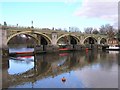
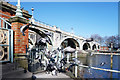
Richmond Half Tide Lock
Richmond's Half Tide Lock opened in 1894. For two hours after the passage of the tide the sluice gates underneath are lowered to block the river. This maintains the water level at a height which enables navigation up to Teddington Lock three miles upstream.
This provided navigable water all hours of the day and meant a yacht club, based on the reach, could be sustained
Image: © Mark Percy
Taken: 4 Dec 2005
0.05 miles
3
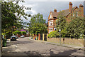
St George's Road, St Margarets
A street of substantial villas in a variety of styles.
Image: © Stephen McKay
Taken: 26 Apr 2017
0.06 miles
5
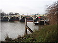
Southern end of Richmond Lock bridge over the Thames
Image: © David Martin
Taken: 22 Jun 2016
0.07 miles
6
Richmond Tide Barrier and Pigeons
The southern corner of the structure is in TQ1674 by a few metres.
Image: © Des Blenkinsopp
Taken: 15 Feb 2018
0.07 miles

9
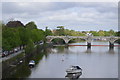
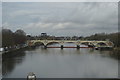
River Thames: Richmond Lock & Footbridge
Richmond Lock is a halftide lock and barrage that also incorporates a public footbridge. The barrage is formed of three vertical sluice gates suspended from the footbridge superstructure. Apart from periods about two hours either side of high tide, the sluice gates are closed and boats have to use the conventional lock on the right side of the photo. Around high tide the sluice gates are raised into the footbridge superstructure and boats can pass through unimpeded. The lock is the most downstream on the River Thames and is the only one to be operated by the Port of London Authority.
Image: © Nigel Cox
Taken: 25 Apr 2006
0.08 miles
10
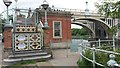
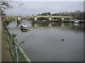
Richmond Lock and half-tide barrier
The level of The Thames between Teddington Lock and Richmond Lock is kept at or above half-tide level by this barrier. Above half-tide the barrier is lowered and boats can pass over it. Below half-tide, as in the photo, the barrier is raised and boats have to use the lock.
Image: © David Hawgood
Taken: 19 Dec 2008
0.08 miles