IMAGES TAKEN NEAR TO
Chatsworth Place, TEDDINGTON, TW11 8NQ
Introduction
This page details the photographs taken nearby to Chatsworth Place, TW11 8NQ by members of the Geograph project.
The Geograph project started in 2005 with the aim of publishing, organising and preserving representative images for every square kilometre of Great Britain, Ireland and the Isle of Man.

There are currently over 7.5m images from over14,400 individuals and you can help contribute to the project by visiting https://www.geograph.org.uk
Image Map
Images are licensed for reuse under creativecommons.org/licenses/by-sa/2.0
Notes
- Clicking on the map will re-center to the selected point.
- The higher the marker number, the further away the image location is from the centre of the postcode.
Image Listing (27 Images Found)
Images are licensed for reuse under creativecommons.org/licenses/by-sa/2.0
Image
Details
Distance
1
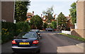
Waldegrave Park, Teddington
This is part of a row of fine old houses, some of which are still in sole occupation. These are viewed from Clavering Close.
Image: © Bill Boaden
Taken: 15 Aug 2010
0.07 miles
2
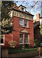
House in Waldegrave Park
One of a number of handsome old red-brick houses (built circa 1900?) which survive in Waldegrave Park. Some are still private residences, but their substantial size means that a number have now found other uses - this one is part of a school. No two seem to be alike - they differ in plan and elevation, and in the detailing of windows and doorways. Most - but not this one - have decorative terracotta panels.
This one faces south, and was lit up by late afternoon sun. Fewer old houses survive on the other side of the street - most properties being of later date, and smaller.
Image: © Stefan Czapski
Taken: 2 Apr 2013
0.19 miles
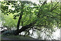
3
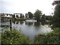
View across the Thames at Ham
Looking towards Teddington
Image: © David Howard
Taken: 27 Jul 2014
0.20 miles
5
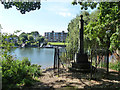
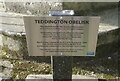
Thames boundary obelisk
Plated 'Lower limit of Thames Conservancy 1900', this is or was where their administration ended and the Port of London Authority took over. The ubiquitous Environment Agency have now assumed Thames Conservancy powers.
Image: © Robin Webster
Taken: 9 Sep 2012
0.22 miles
7
Thames boundary obelisk
Plated 'Lower limit of Thames Conservancy 1900', this is or was where their administration ended and the Port of London Authority took over. The ubiquitous Environment Agency have now assumed Thames Conservancy powers.
Image: © Robin Webster
Taken: 9 Sep 2012
0.22 miles
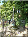
8
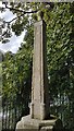
The Teddington Obelisk
On the banks of the River Thames east of Teddington Lock. https://www.geograph.org.uk/photo/7150172
Image: © Ian S
Taken: 2 Apr 2022
0.23 miles
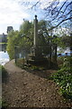
9
Old Boundary Marker north west of Teddington Lock, Richmond
Estate Boundary Marker - Thames Conservancy in the parish of Richmond upon Thames (Richmond upon Thames District), on East bank downstream of Teddington Lock, West of towpath next to the Thames.
Surveyed
Milestone Society National ID: SY_THAC01em.
Image: © Milestone Society
Taken: Unknown
0.23 miles
10
The Teddington Obelisk
On the banks of the River Thames east of Teddington Lock. https://www.geograph.org.uk/photo/7150171
Image: © Ian S
Taken: 2 Apr 2022
0.23 miles