IMAGES TAKEN NEAR TO
Grove Terrace, TEDDINGTON, TW11 8AU
Introduction
This page details the photographs taken nearby to Grove Terrace, TW11 8AU by members of the Geograph project.
The Geograph project started in 2005 with the aim of publishing, organising and preserving representative images for every square kilometre of Great Britain, Ireland and the Isle of Man.

There are currently over 7.5m images from over14,400 individuals and you can help contribute to the project by visiting https://www.geograph.org.uk
Image Map
Images are licensed for reuse under creativecommons.org/licenses/by-sa/2.0
Notes
- Clicking on the map will re-center to the selected point.
- The higher the marker number, the further away the image location is from the centre of the postcode.
Image Listing (69 Images Found)
Images are licensed for reuse under creativecommons.org/licenses/by-sa/2.0
Image
Details
Distance
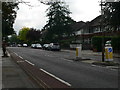
2
View across the Thames at Ham
Looking towards Teddington
Image: © David Howard
Taken: 27 Jul 2014
0.11 miles
3
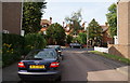
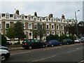
Waldegrave Park, Teddington
This is part of a row of fine old houses, some of which are still in sole occupation. These are viewed from Clavering Close.
Image: © Bill Boaden
Taken: 15 Aug 2010
0.14 miles
4
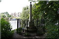
The Teddington Obelisk
Newly restored marker, just below Teddington Lock, which marks the boundary for the Port of London Authority, erected by its predecessor, the Thames Conservancy.
Image: © Mike Pennington
Taken: 15 Aug 2017
0.15 miles
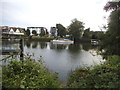
7
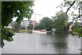
River Thames downstream from Teddington Lock
Image: © N Chadwick
Taken: 25 Aug 2010
0.16 miles

10
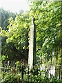
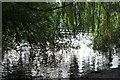
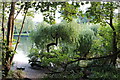
Obelisk near Teddington Lock
Hidden in the trees and somewhat neglected, this obelisk is easy to miss. It marks the boundary between the sections of the Thames controlled by the Port of London Authority (downstream) and the Environment Agency (upstream) respectively. The river itself can be seen in the background.
Image: © David Kemp
Taken: 18 Sep 2008
0.16 miles