IMAGES TAKEN NEAR TO
Cleves Road, RICHMOND, TW10 7NA
Introduction
This page details the photographs taken nearby to Cleves Road, TW10 7NA by members of the Geograph project.
The Geograph project started in 2005 with the aim of publishing, organising and preserving representative images for every square kilometre of Great Britain, Ireland and the Isle of Man.

There are currently over 7.5m images from over14,400 individuals and you can help contribute to the project by visiting https://www.geograph.org.uk
Image Map
Images are licensed for reuse under creativecommons.org/licenses/by-sa/2.0
Notes
- Clicking on the map will re-center to the selected point.
- The higher the marker number, the further away the image location is from the centre of the postcode.
Image Listing (107 Images Found)
Images are licensed for reuse under creativecommons.org/licenses/by-sa/2.0
Image
Details
Distance
1

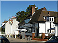
Ham Street and the Ham Brewery Tap
View north-west, from a point close to the junction with Lock Road.
Not far behind the camera there's a cottage called Image, while the pub is known as the Brewery Tap. Those two names taken together amount to pretty good evidence that there was once a brewery here. The pub looks as if it dates from the 1920s or '30s - a period of rapid residential development around Ham and Petersham.
Image: © Stefan Czapski
Taken: 30 Jan 2016
0.10 miles
2
The Ham Brewery Tap
On Ham Street, just off Ham Common.
Image: © Robin Webster
Taken: 22 Sep 2012
0.11 miles
3
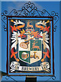
The Ham Brewery Tap inn sign
For the rest of the pub, see Image
Image: © Robin Webster
Taken: 22 Sep 2012
0.11 miles
4
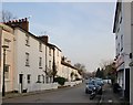
Ham Street: view south-eastwards towards the Common
Looking towards the Ham Brewery Tap, and - beyond it - the Common. I can't say whether the narrow weather-boarded frontage on the left pre-dates its neighbours, but such buildings are a noticeable feature in 19th-century photos of the Ham and Richmond area. Few now remain, but one is shown in Image
Image: © Stefan Czapski
Taken: 11 Mar 2016
0.11 miles

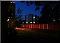
8
Ham Close at dusk
The housing estate from the adjacent village green.
Image: © David Howard
Taken: 23 Sep 2018
0.12 miles
10
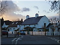
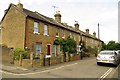
The Malthouse, Lock Road
At the corner of Lock Road and Ham Street. The cottage has an unusual form of gambrel roof (rising less steeply from the eaves than is usual) and has 'kneelers' at the near gable-end - all of which suggests a certain antiquity.
Image: © Stefan Czapski
Taken: 30 Jan 2016
0.13 miles