IMAGES TAKEN NEAR TO
York Road, RICHMOND, TW10 6DR
Introduction
This page details the photographs taken nearby to York Road, TW10 6DR by members of the Geograph project.
The Geograph project started in 2005 with the aim of publishing, organising and preserving representative images for every square kilometre of Great Britain, Ireland and the Isle of Man.

There are currently over 7.5m images from over14,400 individuals and you can help contribute to the project by visiting https://www.geograph.org.uk
Image Map
Images are licensed for reuse under creativecommons.org/licenses/by-sa/2.0
Notes
- Clicking on the map will re-center to the selected point.
- The higher the marker number, the further away the image location is from the centre of the postcode.
Image Listing (104 Images Found)
Images are licensed for reuse under creativecommons.org/licenses/by-sa/2.0
Image
Details
Distance
1
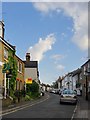
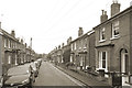
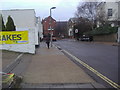
Prince's Road, Richmond
For the most part a street of early-Victorian terraced cottages. In the middle distance the building with the high Dutch-style gable was originally a school. In the foreground, plenty of evidence of a brisk housing market in this part of the world.
Image: © Stefan Czapski
Taken: 13 Jul 2014
0.02 miles
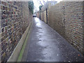
3
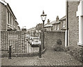
End of Houblon Road
Houblon Road is a no through road for vehicles but there is pedestrian access through to Church Road.
Image: © Des Blenkinsopp
Taken: 19 Oct 2017
0.06 miles
5
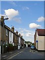
Worple Way, Richmond
One of a number of cottagey back doubles in this area. The street comes to a dead end, but the name then applies to a passageway that continues to King's Road and beyond. The name Worple Way suggests a medieval origin, as a track leading to the parish's open fields.
Image: © Stefan Czapski
Taken: 13 Jul 2014
0.11 miles
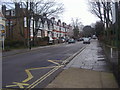
6
Kings Road Richmond
Looking at junction of Sheen Road
Image: © David Howard
Taken: 21 Feb 2011
0.12 miles
7
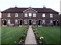
The Houblon Almshouses, Richmond
The formal design, the dark brickwork, and the small first-floor windows all contribute to a rather stern impression - a little barracks. A tablet over the porch in the middle dates the building to 1758, and reads as follows:
THESE ALMS-HOUSES WERE ERECTED AND ENDOWED BY MRS. REBECCA AND MRS. SUSANNAH HOUBLON
M.DCC.LVIII
The site lies on the boundary of the grid-square. The 1:25,000 sheet suggests that it belongs in this square rather then the next to the north.
Image: © Stefan Czapski
Taken: 20 Mar 2011
0.12 miles