IMAGES TAKEN NEAR TO
Fraddon, ST. COLUMB, TR9 6EY
Introduction
This page details the photographs taken nearby to TR9 6EY by members of the Geograph project.
The Geograph project started in 2005 with the aim of publishing, organising and preserving representative images for every square kilometre of Great Britain, Ireland and the Isle of Man.

There are currently over 7.5m images from over14,400 individuals and you can help contribute to the project by visiting https://www.geograph.org.uk
Image Map
Images are licensed for reuse under creativecommons.org/licenses/by-sa/2.0
Notes
- Clicking on the map will re-center to the selected point.
- The higher the marker number, the further away the image location is from the centre of the postcode.
Image Listing (6 Images Found)
Images are licensed for reuse under creativecommons.org/licenses/by-sa/2.0
Image
Details
Distance
1
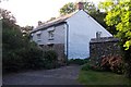
Trevuzza Farm
The wonderfully named hamlet of Trevuzza is a collection of no more than a couple farm cottages. The photogenic Trevuzza Mill is alas in the next square !
Image: © Anthony Jeffrey
Taken: 15 Sep 2007
0.03 miles
2
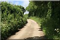
Barton Lane nr Trevuzza
Typical Cornish lane nr Indian Queens
Image: © roger geach
Taken: 24 Jun 2012
0.09 miles
3
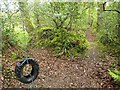
Tyre by the path near Mill Ennis
A tempting swing by the hard-to-follow footpath 417/6/1, classified silver, soon after it leaves Barton Lane.
Image: © Derek Harper
Taken: 14 May 2010
0.20 miles
4
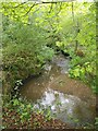
Stream near Mill Ennis
This seems to be where footpath 417/6/1 crosses this stream, a tributary of the River Gunnel, but there was no obvious way across, so I continued along the south side, not without difficulty. Footpath 417/6/1 is classified silver, making you wonder about the wisdom of trying to follow a bronze footpath. Naturally, the OS map does not distinguish between these classifications; Cornwall really needs to rethink its footpath policy if it is to attract walkers.
Image: © Derek Harper
Taken: 14 May 2010
0.21 miles
5
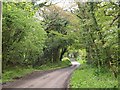
Barton Lane
A winding lane from Fraddon to White Cross, here passing Mill Ennis and crossing a tributary of the River Gunnel through an area of woodland.
Image: © Derek Harper
Taken: 14 May 2010
0.22 miles
6
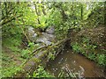
Stream below Mill Ennis
See Image; this was where I managed to cross the stream, using the fallen tree, to regain the official line of footpath 417/6/1 as shown on the map.
Image: © Derek Harper
Taken: 14 May 2010
0.22 miles