IMAGES TAKEN NEAR TO
Ashprington, TOTNES, TQ9 7UL
Introduction
This page details the photographs taken nearby to TQ9 7UL by members of the Geograph project.
The Geograph project started in 2005 with the aim of publishing, organising and preserving representative images for every square kilometre of Great Britain, Ireland and the Isle of Man.

There are currently over 7.5m images from over14,400 individuals and you can help contribute to the project by visiting https://www.geograph.org.uk
Image Map
Images are licensed for reuse under creativecommons.org/licenses/by-sa/2.0
Notes
- Clicking on the map will re-center to the selected point.
- The higher the marker number, the further away the image location is from the centre of the postcode.
Image Listing (89 Images Found)
Images are licensed for reuse under creativecommons.org/licenses/by-sa/2.0
Image
Details
Distance
1
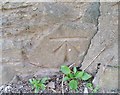
Ordnance Survey Cut Mark
This OS cut mark can be found on Coombe House NW side of the road. It marks a point 63.575m above mean sea level.
Image: © Adrian Dust
Taken: 25 Mar 2019
0.03 miles
2
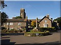
Ashprington
In the foreground is the war memorial shown in Image On the left is the row of estate cottages described at http://www.imagesofengland.org.uk/details/default.aspx?id=100924 . "All the windows are in their C19 openings with red brick cambered arches." To the right is Corner Cottage with "original 2-light casements with lozenge and diamond-shaped panes" http://www.imagesofengland.org.uk/Details/Default.aspx?id=100925&mode=adv . "Ashprington is the estate village of Sharpham House". Behind is Image
Image: © Derek Harper
Taken: 27 Sep 2009
0.04 miles
3
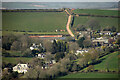
Ashprington from near Tideford
From about three kilometres away on a crop tramline that will hopefully lead us from Cornworthy footpath 5 to footpath 7. The church https://historicengland.org.uk/listing/the-list/list-entry/1108393 was almost impossible to detect with the naked eye, but a little later became much easier to see when a flag was raised on the tower.
Image: © Derek Harper
Taken: 22 Apr 2021
0.04 miles
4
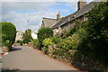
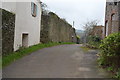
Ashprington Village
Going uphill towards the village centre on the road from Bow Bridge.
Image: © Tony Atkin
Taken: 27 Aug 2008
0.04 miles
6
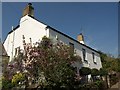
Brooking House, Ashprington
This C18 house faces the steep hill up through the village http://www.britishlistedbuildings.co.uk/en-100934-brooking-house-ashprington .
Image: © Derek Harper
Taken: 20 Apr 2011
0.06 miles
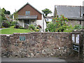
7
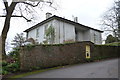
Ashprington House
Grade II listed. https://www.britishlistedbuildings.co.uk/101108390-ashprington-house-ashprington
Image: © N Chadwick
Taken: 13 Jan 2018
0.07 miles
8
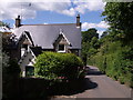
Cottage, Ashprington
One of the last buildings in the village on the hill leading down to Bow Bridge, with attractive bargeboards on the gables.
Image: © Derek Harper
Taken: 28 May 2007
0.08 miles
10
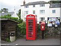
Communications hub, Ashprington
A bus shelter and a village noticeboard frame a K6 phone box and postbox number TQ9 57.
Image: © Robin Stott
Taken: 19 Jul 2011
0.08 miles