IMAGES TAKEN NEAR TO
Hernaford Road, TOTNES, TQ9 7TX
Introduction
This page details the photographs taken nearby to Hernaford Road, TQ9 7TX by members of the Geograph project.
The Geograph project started in 2005 with the aim of publishing, organising and preserving representative images for every square kilometre of Great Britain, Ireland and the Isle of Man.

There are currently over 7.5m images from over14,400 individuals and you can help contribute to the project by visiting https://www.geograph.org.uk
Image Map
Images are licensed for reuse under creativecommons.org/licenses/by-sa/2.0
Notes
- Clicking on the map will re-center to the selected point.
- The higher the marker number, the further away the image location is from the centre of the postcode.
Image Listing (56 Images Found)
Images are licensed for reuse under creativecommons.org/licenses/by-sa/2.0
Image
Details
Distance
1
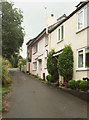
Hernaford Lane, Harbertonford
A cul-de-sac for vehicles off Old Road, though as a route with public access it reaches the farm and lane at Hernaford.
Image: © Derek Harper
Taken: 12 Aug 2018
0.00 miles
2
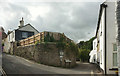
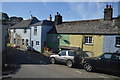
Junction, Harbertonford
The through lane, for Boreston and Moreleigh, climbs left here; the right turn along Woodcourt Road is a public access route to the farm of that name.
Image: © Derek Harper
Taken: 12 Aug 2018
0.02 miles
3
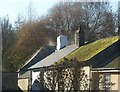
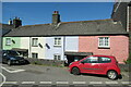
Roofs in Harbertonford
Steaming in the warm sunshine, these roofs are on houses in Brook Villas. Seen from the top deck of an X64 bus, bound for Kingsbridge.
Image: © Derek Harper
Taken: 25 Nov 2010
0.03 miles
4
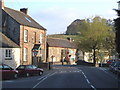
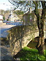
A381 at Harbertonford
The main road between Totnes and Kingsbridge swings across the River Harbourne in this village.
Image: © Derek Harper
Taken: 29 Apr 2006
0.04 miles
6
Harbertonford
The bridge over the River Harbourne, with the Victorian church and the Maltsters Arms on either side of the A381. The river bed beneath the bridge was considerably deepened a few years ago as part of a major flood defence scheme (sandbags used to be a frequent sight in neighbouring streets) after it was discovered that the bridge itself was a bottleneck for the river. https://restorerivers.eu/wiki/index.php?title=Case_study%3AHarbertonford_Flood_Alleviation_Scheme : "Channel lowered by 600mm through Harbertonford using pool-riffle sequences, to increase channel capacity, to withstand 28 cumec flow (1:10 year event). Also widened in areas to further increase capacity."
Image: © Derek Harper
Taken: 29 Apr 2006
0.05 miles
8
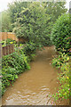
Harbourne River, Harbertonford
Looking upstream from Harbertonford Bridge. The river is very muddy after rain.
Image: © Derek Harper
Taken: 12 Aug 2018
0.06 miles
9
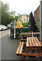
Unused picnic tables, Harbertonford
Hardly surprising on a dismal Sunday. The signpost seems to have migrated across the A381 since Image was taken.
Image: © Derek Harper
Taken: 12 Aug 2018
0.07 miles
10
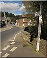
A381 at Harbertonford
A similar view to Image, again with the bridge over the Harbourne http://www.britishlistedbuildings.co.uk/en-101331-harbertonford-bridge-harberton-devon and the Maltsters Arms http://www.britishlistedbuildings.co.uk/en-101332-floyd-s-inn-harberton-devon . St Peter's church is described at http://www.britishlistedbuildings.co.uk/en-101335-church-of-st-peter-harberton-devon .
Image: © Derek Harper
Taken: 19 Sep 2012
0.07 miles