IMAGES TAKEN NEAR TO
Dittisham, DARTMOUTH, TQ6 0JG
Introduction
This page details the photographs taken nearby to TQ6 0JG by members of the Geograph project.
The Geograph project started in 2005 with the aim of publishing, organising and preserving representative images for every square kilometre of Great Britain, Ireland and the Isle of Man.

There are currently over 7.5m images from over14,400 individuals and you can help contribute to the project by visiting https://www.geograph.org.uk
Image Map
Images are licensed for reuse under creativecommons.org/licenses/by-sa/2.0
Notes
- Clicking on the map will re-center to the selected point.
- The higher the marker number, the further away the image location is from the centre of the postcode.
Image Listing (27 Images Found)
Images are licensed for reuse under creativecommons.org/licenses/by-sa/2.0
Image
Details
Distance
1

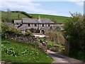
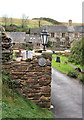
Bozomzeal
Shown on maps as "Bosomzeal", this farm complex is centred on a medieval house. Taken from the lane which also serves as an arm of the Dart Valley Trail.
Image: © Derek Harper
Taken: 23 Jun 2006
0.01 miles
2
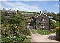
Bozomzeal
Or Bosomzeal. See also Image and Image The attractive farmhouse sits so neatly in the valley head that it is difficult to resist taking further photographs. There is a detailed listed building description at http://www.imagesofengland.org.uk/Details/Default.aspx?id=101161&mode=adv .
Image: © Derek Harper
Taken: 3 May 2010
0.02 miles
3
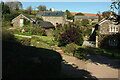
Bozomzeal
Another view of part of the buildings also shown in Image, Image and Image This is The Linhay. http://www.imagesofengland.org.uk/Details/Default.aspx?id=101161&mode=adv
Image: © Derek Harper
Taken: 3 May 2010
0.03 miles
4
Bozomzeal
Fourteen years on from Image; there've been some arboreal alterations, and some redecoration. The listed farmhouse is shown on the EH map as the building on the right, but in fact must be the building shown in Image, which is here largely hidden on the left https://historicengland.org.uk/listing/the-list/list-entry/1108283 . Seen from the Dart Valley Trail.
Image: © Derek Harper
Taken: 27 Sep 2020
0.03 miles
5
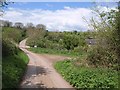
Lane at Bosomzeal
The lane, which carries the Dart Valley Trail, swings across the shallow valley head past Image
Image: © Derek Harper
Taken: 3 May 2010
0.04 miles
6
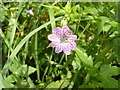
Geranium versicolor at Bozomzeal
Pencilled Cranesbill - a fairly rare garden escape, but less so here in the southwest.
Image: © Derek Harper
Taken: 23 Jun 2006
0.05 miles
7
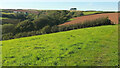
Valley at Bosomzeal
From the Dart Valley Trail, with Higher Bosomzeale Farm on the left; Bosomzeal itself is hidden by trees.
Image: © Derek Harper
Taken: 27 Sep 2020
0.06 miles
8
Listed Building Sign at Bozomzeal
Bozomzeal seems to be spelled differently from the Bosomzeal pig farm opposite
Image: © Geoff Gartside
Taken: 26 Oct 2008
0.07 miles
9
Trees near Bosomzeal
Looking right from the Dart Valley Trail on the far side of the field shown in Image], with Higher Bosomzeale Farm visible across the valley.
Image: © Derek Harper
Taken: 27 Sep 2020
0.07 miles
10
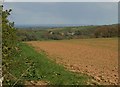
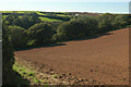
Field above Bozomzeal
From the Dart Valley Trail on the ridge between Bozomzeal and the Dart. The river is invisible; the converted farm beyond it is Higher Greenway, in Image Tankers lie in Tor Bay.
Image: © Derek Harper
Taken: 3 May 2010
0.10 miles