IMAGES TAKEN NEAR TO
Bridge Road, DARTMOUTH, TQ6 0DZ
Introduction
This page details the photographs taken nearby to Bridge Road, TQ6 0DZ by members of the Geograph project.
The Geograph project started in 2005 with the aim of publishing, organising and preserving representative images for every square kilometre of Great Britain, Ireland and the Isle of Man.

There are currently over 7.5m images from over14,400 individuals and you can help contribute to the project by visiting https://www.geograph.org.uk
Image Map
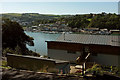
Images are licensed for reuse under creativecommons.org/licenses/by-sa/2.0
Notes
- Clicking on the map will re-center to the selected point.
- The higher the marker number, the further away the image location is from the centre of the postcode.
Image Listing (168 Images Found)
Images are licensed for reuse under creativecommons.org/licenses/by-sa/2.0
Image
Details
Distance
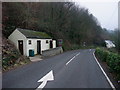
1
House on Bridge Road
With a good view over the River Dart to northern Dartmouth and the naval college.
Image: © Derek Harper
Taken: 17 Sep 2019
0.00 miles
2
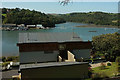
House on Bridge Road
Another view of the house shown in Image], this time with the backdrop of Old Mill Creek across the river, and the spit extending out from Rough Hole Point.
Image: © Derek Harper
Taken: 17 Sep 2019
0.00 miles
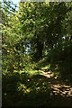
4
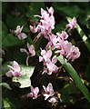
Cyclamen, Dart Valley Trail
Lower down the path shown in Image
Image: © Derek Harper
Taken: 17 Sep 2019
0.03 miles
5
Dart Valley Trail above Britannia Crossing
Climbing a permissive path to meet the track shown in Image
Image: © Derek Harper
Taken: 17 Sep 2019
0.04 miles
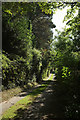
6
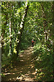
Dart Valley Trail above Britannia Crossing
Looking left from the bend in the path where Image] was taken, down the Trail as it drops steeply to meet Bridge Road close to the ferry crossing.
Image: © Derek Harper
Taken: 17 Sep 2019
0.04 miles
7
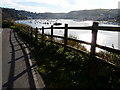
Kingswear and Dartmouth
The road down to the higher ferry on the Kingswear side gives a good view of the marina, the two towns and the wide river which made the port an important military base. Noss Quay, a little further up on the Kingswear side, is a deep water port.
Image: © Tom Jolliffe
Taken: 19 Nov 2008
0.05 miles
8
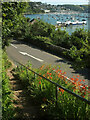
A379 approaching the Higher Ferry
Just missed one. Taken from the Dart Valley Trail descending from Kingswear footpath 30.
Image: © Derek Harper
Taken: 4 Aug 2021
0.05 miles
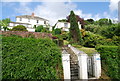
9
Public conveniences on the Dart Valley Trail
After leaving its trackside position along the Paignton and Dartmouth Steam Railway, the Trail follows a short section of road before heading uphill into the woods.
Image: © Tim Heaton
Taken: 9 Feb 2011
0.05 miles
10
Footpath to Kingswear
Kingswear footpath 30 continues the line of the road shown in Image], seen here from the point where the Dart Valley Trail leaves it, dropping steeply through a wood on the right.
Image: © Derek Harper
Taken: 17 Sep 2019
0.06 miles