IMAGES TAKEN NEAR TO
Wyre Close, PAIGNTON, TQ4 7RU
Introduction
This page details the photographs taken nearby to Wyre Close, TQ4 7RU by members of the Geograph project.
The Geograph project started in 2005 with the aim of publishing, organising and preserving representative images for every square kilometre of Great Britain, Ireland and the Isle of Man.

There are currently over 7.5m images from over14,400 individuals and you can help contribute to the project by visiting https://www.geograph.org.uk
Image Map
Images are licensed for reuse under creativecommons.org/licenses/by-sa/2.0
Notes
- Clicking on the map will re-center to the selected point.
- The higher the marker number, the further away the image location is from the centre of the postcode.
Image Listing (20 Images Found)
Images are licensed for reuse under creativecommons.org/licenses/by-sa/2.0
Image
Details
Distance
1
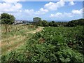
Open space above Roselands Road
The path leading to Roselands Road crosses this hill with fine views over Tor Bay. This area forms part of a crucial green space comprising several fields between Paignton Zoo and the estates of housing Roselands and Goodrington, and various caravan parks and sports facilities.
Image: © Derek Harper
Taken: 1 Aug 2008
0.14 miles
2
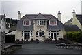
158 Goodrington Road, Paignton
158 Goodrington Road is a large detached property in Paignton, Devon, England. In this shot, its windows are decorated with flags and banners of Liverpool Football Club.
Image: © Steven Haslington
Taken: 17 Sep 2012
0.16 miles
3
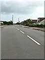
Goodrington Road
Bit of a rat run connecting the Dartmouth road and the Brixham road.
Image: © jeff collins
Taken: 21 Jun 2020
0.16 miles
4

Path near Roselands estate
The north-east corner of this square includes a fragment of the open space between the Roselands estate and Goodrington / Clennon. Here a path, part of a circular countryside walk, crosses between fields. On the right is a fence bordering properties on Hennock Road.
Image: © Derek Harper
Taken: 1 Aug 2008
0.18 miles
5
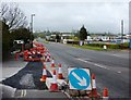
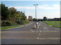
Clayland Cross Road Widening
The road widening which runs from Tweenaway Cross up to the South Devon College vicinity can be seen here towards its end near the South Devon College turning off the ring road which is to the right ahead.
Image: © Tom Jolliffe
Taken: 3 Apr 2011
0.19 miles
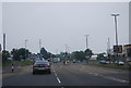
6

Houses on Brixham Road
A brace of semi-detached pairs with distinctive flat roofs, opposite the derelict site shown in Image
Image: © Derek Harper
Taken: 21 Jun 2017
0.20 miles
9
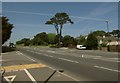
Brixham Road
A tall pine makes a distinctive feature on the A3022 as it passes the vacant site shown in Image
Image: © Derek Harper
Taken: 21 Jun 2017
0.22 miles
10
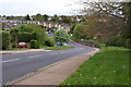
Roselands Drive
Part of a large estate west of Goodrington, seen from the start of a short footpath that links to the nearby Brixham Road.
Image: © Derek Harper
Taken: 30 Apr 2009
0.22 miles