IMAGES TAKEN NEAR TO
Blagdon, PAIGNTON, TQ3 3YD
Introduction
This page details the photographs taken nearby to TQ3 3YD by members of the Geograph project.
The Geograph project started in 2005 with the aim of publishing, organising and preserving representative images for every square kilometre of Great Britain, Ireland and the Isle of Man.

There are currently over 7.5m images from over14,400 individuals and you can help contribute to the project by visiting https://www.geograph.org.uk
Image Map
Images are licensed for reuse under creativecommons.org/licenses/by-sa/2.0
Notes
- Clicking on the map will re-center to the selected point.
- The higher the marker number, the further away the image location is from the centre of the postcode.
Image Listing (19 Images Found)
Images are licensed for reuse under creativecommons.org/licenses/by-sa/2.0
Image
Details
Distance
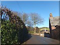
1
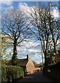
Cottage at Middle Blagdon
Looking down Blagdon Road. The cottage is at the junction with Middle Blagdon Lane.
Image: © Derek Harper
Taken: 5 Apr 2008
0.02 miles
2
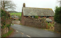
Pound House, Blagdon
"A cider house, now converted to a house. C18, converted 1980s" https://historicengland.org.uk/listing/the-list/list-entry/1207456 . In the left background is the listed dairy https://historicengland.org.uk/listing/the-list/list-entry/1195089 seen in Image
Image shows part of this scene on a much sunnier Boxing Day.
Image: © Derek Harper
Taken: 22 Nov 2020
0.02 miles
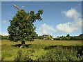
3
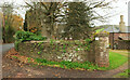
Middle Blagdon
Beyond the curving wall, on the right, is the listed dairy, "Part of a large planned double-courtyard split-level farmyard, still in agricultural use and a rare survival in Devon" https://historicengland.org.uk/listing/the-list/list-entry/1195089 . The farmhouse, also listed https://historicengland.org.uk/listing/the-list/list-entry/1195088, is behind the Araucaria. See also Image and Image
Image: © Derek Harper
Taken: 22 Nov 2020
0.03 miles
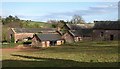
4
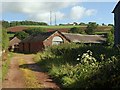
Middle Blagdon
Another part of the extensive range of farm buildings seen in Image, this time from Middle Blagdon Lane. "A rare example in Devon of a large-scale split-level Victorian farmyard, still in agricultural use, and relatively unaltered" https://historicengland.org.uk/listing/the-list/list-entry/1207438 .
Image: © Derek Harper
Taken: 19 Jun 2008
0.03 miles
5
Middle Blagdon
The road on the right leads to Lower Blagdon, while the main road leads to Higher Blagdon
Image: © David Smith
Taken: 26 Dec 2013
0.03 miles
6
Walnut Cottage, Blagdon
The listed cottage is seen past a disfigured tree from the short footpath connecting Lower and Middle Blagdon Lanes. "This is a good example of a simple vernacular house of the early C18" https://historicengland.org.uk/listing/the-list/list-entry/1208066 .
Image: © Derek Harper
Taken: 19 Jun 2008
0.05 miles
7
Middle Blagdon
Farm buildings at Middle Blagdon seen from Bell Lane. "Part of a large planned farmyard, still in agricultural use and a rare survival of a split-level Victorian farmyard in Devon" https://historicengland.org.uk/listing/the-list/list-entry/1195091 . See also Image
Image: © Derek Harper
Taken: 5 Apr 2008
0.06 miles
8
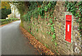
Postbox, Blagdon
Edward VII postbox TQ3 132 is on Blagdon Road at Middle Blagdon, and is shown in close-up at Image
Image: © Derek Harper
Taken: 22 Nov 2020
0.06 miles
9
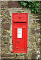
Postbox, Blagdon
A close look at the Edward VII postbox TQ3 132 shown in Image
Image: © Derek Harper
Taken: 22 Nov 2020
0.06 miles
10
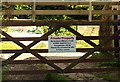
Warning notice, Blagdon
I don't think it would occur to passers-by that anyone would want to enter this gate, until they saw this notice and became curious. Note that you will be "Physically arrested" with a capital P. Shall I give you the address for a fixed written appointment...?
Image: © Derek Harper
Taken: 19 Jun 2008
0.07 miles