IMAGES TAKEN NEAR TO
Dunning Walk, TEIGNMOUTH, TQ14 9LN
Introduction
This page details the photographs taken nearby to Dunning Walk, TQ14 9LN by members of the Geograph project.
The Geograph project started in 2005 with the aim of publishing, organising and preserving representative images for every square kilometre of Great Britain, Ireland and the Isle of Man.

There are currently over 7.5m images from over14,400 individuals and you can help contribute to the project by visiting https://www.geograph.org.uk
Image Map
Images are licensed for reuse under creativecommons.org/licenses/by-sa/2.0
Notes
- Clicking on the map will re-center to the selected point.
- The higher the marker number, the further away the image location is from the centre of the postcode.
Image Listing (69 Images Found)
Images are licensed for reuse under creativecommons.org/licenses/by-sa/2.0
Image
Details
Distance
1
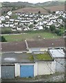
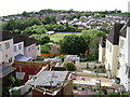
Below Higher Coombe Drive
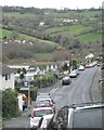
Beyond the rooftops of Deer Park Avenue is a match in progress on Teignmouth Football Club's ground off Coombe Park Road http://www.geograph.org.uk/photo/1317980 Across the Coombe valley is the Moor View Drive estate creeping up the hillside towards Headway Cross Image In the distance are the outskirts of Bishopsteignton and a glimpse of blue hills. For a wider view see http://www.geograph.org.uk/photo/1165497
Image: © Robin Stott
Taken: 9 Dec 2012
0.05 miles
2
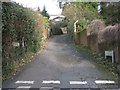
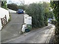
Lower end of Rocky Lane, Teignmouth
It becomes a footpath, climbing steeply to meet the Exeter Road.
Image: © Robin Stott
Taken: 11 Dec 2012
0.06 miles
3
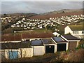
Garages, Higher Coombe Drive
There is an overlap on the right with Image The houses behind the garages face Deer Park Avenue. In the bottom of the Bitton Brook valley is the football ground beside Coombe Lane. The housing on Moorview Drive beyond is in Image and Image
Image: © Derek Harper
Taken: 13 Feb 2009
0.06 miles
4
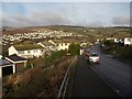
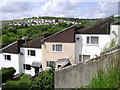
Higher Coombe Drive, Teignmouth
The southern end of the road, dropping from the junction with Exeter Road, gives a good view across the Bitton Brook valley to housing along Moorview Drive, and up to Little Haldon.
Image: © Derek Harper
Taken: 13 Feb 2009
0.06 miles
5
Houses and gardens below Nelson Close, Teignmouth
Looking across the football club's ground to the Moor View Drive estate, right, and the line of Headway Cross Road running up to the junction with Shepherds' Lane and Mill Lane on the skyline.
Image: © Robin Stott
Taken: 19 May 2009
0.07 miles
6
Monopitch-roof houses, Teignmouth
Several rows? stacks? of these houses descend from Nelson Close and Lake Avenue.
Beyond, a surviving part of the Coombe Valley with the dominating Moor View Drive estate above.
Image: © Robin Stott
Taken: 19 May 2009
0.07 miles
7
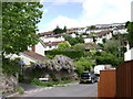
Housing above Headway Cross Road, Teignmouth
Coombe Lane, left. The viewpoint is the corner of Hope's Close, which appears in Image
Image: © Robin Stott
Taken: 19 May 2009
0.07 miles
8
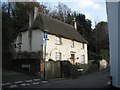
Quarry Cottage, 128 Coombe Vale Road, Teignmouth
Seen from the east end of Headway Cross Road; Rocky Lane climbs the hill, left.
Image: © Robin Stott
Taken: 11 Dec 2012
0.08 miles
9
Along Higher Coombe Drive
Holcombe Down on the skyline Image
Image: © Robin Stott
Taken: 9 Dec 2012
0.10 miles
10
Coombe Vale Road, Teignmouth, and drive to No.124
Many properties on the upslope side of the road have steep drives or flights of steps to their front doors. Front gardens are often bounded by retaining walls.
Image: © Robin Stott
Taken: 11 Dec 2012
0.10 miles