IMAGES TAKEN NEAR TO
Lower Kingsdown Road, TEIGNMOUTH, TQ14 9AP
Introduction
This page details the photographs taken nearby to Lower Kingsdown Road, TQ14 9AP by members of the Geograph project.
The Geograph project started in 2005 with the aim of publishing, organising and preserving representative images for every square kilometre of Great Britain, Ireland and the Isle of Man.

There are currently over 7.5m images from over14,400 individuals and you can help contribute to the project by visiting https://www.geograph.org.uk
Image Map
Images are licensed for reuse under creativecommons.org/licenses/by-sa/2.0
Notes
- Clicking on the map will re-center to the selected point.
- The higher the marker number, the further away the image location is from the centre of the postcode.
Image Listing (179 Images Found)
Images are licensed for reuse under creativecommons.org/licenses/by-sa/2.0
Image
Details
Distance
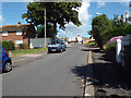
1
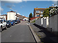
Looking down Kingsway, Teignmouth
Kingsway perches on the steep eastern slope of the Broadmeadow valley. Blocks of flats, right, look out over open countryside.
Image: © Robin Stott
Taken: 19 May 2009
0.06 miles
2
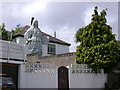
The Lady of Lyonesse
A sculpture in the garden of 'Lyonesse', No 1, Higher Kingsdown Road, Teignmouth. It is steadied by multiple guy wires, washing lines and so forth. The inscription on the tablet reads: "Your honesty and self-respect contribute to safe and happy environments". Whether this is addressed to the world at large or to a specific neighbour, who can say? As seen from Mill Lane; for another view, including the mermaid on the roof, see Image
Difficult to photograph. I was a good hour late to get a more oblique light but there was just too much other stuff to photograph on the way!
Image: © Robin Stott
Taken: 19 May 2009
0.06 miles
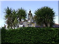
3
A surprising sight from Mill Lane, Teignmouth
Image: © Robin Stott
Taken: 20 May 2009
0.06 miles
4
The Mermaid of Lyonesse
Perched smiling on the chimney of 'Lyonesse', 1 Higher Kingsdown Road, Teignmouth. Her companion is at Image and both at Image An improvement on gnomes.
Image: © Robin Stott
Taken: 20 May 2009
0.06 miles
5
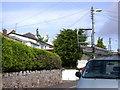
Flats and houses, Kingsway, Teignmouth
This area has seen a lot of change since the 1950s when the OS map showed a very uniform layout of short terraces as in Image The first turning on the right is Lower Kingsdown Road.
Image: © Robin Stott
Taken: 8 Jul 2014
0.07 miles
6
Open space between houses, below Kingsway, Teignmouth
As Kingsway climbs steeply, views open. On the left there is a glimpse of the Teign estuary and, left of centre, Newfoundland Road, the access to the recently-built Morrisons supermarket and sports pitches at Broadmeadow; the yellow vehicle is an AA van. At upper right is the house called The Lea and at centre is the realigned lane of the same name; its lower end is in Image Some of the early council houses off Kingsway, not yet replaced, are seen in Image
Image: © Robin Stott
Taken: 8 Jul 2014
0.07 miles
7
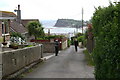
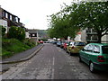
Kingsdown Road, Teignmouth
Once again, the Ness upstages the town. This is one of several roads in the area with streetnames and services, seemingly, but which raise a doubt as to whether they are adopted public highways. These two lads were delivering flyers. They were interested to hear about Geograph but disbelieving of my liking for the foreground here as well as the distance – the scruffy road, the wires, the assorted boundary treatments, the ad hoc nature of it all. I met them again hours later rounding the corner of Alexandra Terrace in Image We had all walked a long way.
Image: © Robin Stott
Taken: 19 May 2009
0.08 miles
8
Flat-roofed two-storey terraced houses off Kingsway, Teignmouth
Image: © Robin Stott
Taken: 8 Jul 2014
0.09 miles
9
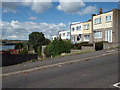
Lower end of Kingsway, Teignmouth
A group of lock-up garages sits beside a conventional brick council house, left.
Image: © Robin Stott
Taken: 8 Jul 2014
0.10 miles
10
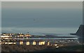
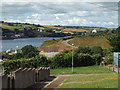
Flats above Broadmeadow and Teignmouth
The view from beside Beacon Park Plantation over Teignmouth in the late afternoon sun. The flats are along Broadmeadow View and Kingsway. Beyond them is part of Teignmouth on the spit across the mouth of the River Teign, with The Ness on the right.
Image: © Derek Harper
Taken: 27 Jan 2008
0.10 miles