IMAGES TAKEN NEAR TO
Buckeridge Road, TEIGNMOUTH, TQ14 8NX
Introduction
This page details the photographs taken nearby to Buckeridge Road, TQ14 8NX by members of the Geograph project.
The Geograph project started in 2005 with the aim of publishing, organising and preserving representative images for every square kilometre of Great Britain, Ireland and the Isle of Man.

There are currently over 7.5m images from over14,400 individuals and you can help contribute to the project by visiting https://www.geograph.org.uk
Image Map
Images are licensed for reuse under creativecommons.org/licenses/by-sa/2.0
Notes
- Clicking on the map will re-center to the selected point.
- The higher the marker number, the further away the image location is from the centre of the postcode.
Image Listing (169 Images Found)
Images are licensed for reuse under creativecommons.org/licenses/by-sa/2.0
Image
Details
Distance
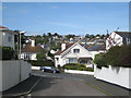
1
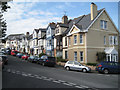
South end of Buckeridge Road
Three-storey bays distinguish this terrace of houses at the steep south end of Buckeridge Road. The view is from Higher Brimley at the junction with Lower Brimley Road and Haldon Avenue, right.
Image: © Robin Stott
Taken: 6 May 2012
0.01 miles
2
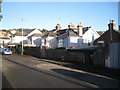
Rear of houses in Buckeridge Road from West Buckeridge
Teignmouth's suburbs are on a generally south-facing steep hillside (or valley side). It is common for rear access to houses to be at first floor level, as here. West Buckeridge follows the contours: perhaps it was laid out in the days of horse-drawn traffic. Its modern neighbour, The Mount, charges up the steep hillside. Would Teignmouth's suburbs have spread as far as they have without the car and the bus?
Image: © Robin Stott
Taken: 10 Dec 2012
0.02 miles
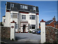
3
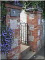
Polychrome gate pillars, Higher Brimley
The commonly-seen rich orange brick contrasts with blocks of pale grey Devonian limestone.
Image: © Robin Stott
Taken: 6 May 2012
0.02 miles
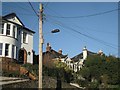
4
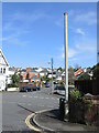
Vent pipe on Higher Brimley
At the junction of Lower Brimley Road is a stink pipe, one of several in the town. Note also in the background a more modern street standard.
Image: © Neil Owen
Taken: 30 Mar 2024
0.03 miles
5
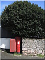
Lower Brimley Road post box
A George V version with a drop box attached.
Image: © Neil Owen
Taken: 30 Mar 2024
0.03 miles
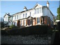
6
Modernising a Victorian villa (Eastbrook House)
What could possibly go wrong?
Image: © Robin Stott
Taken: 6 May 2012
0.04 miles
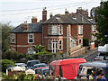
7
Big old semi-detached houses, Higher Brimley
Image: © Robin Stott
Taken: 10 Dec 2012
0.04 miles
8
No.96 Higher Brimley seen from Buckeridge Road
This substantial villa in polychrome brick is a feature at the north end of Higher Brimley. The hard, cream Kingsteignton brick is used for strength at corners, around window and door openings, between storeys and in chimneys. The middle of Higher Brimley Terrace is seen in Image and its south end is seen in Image
Image: © Robin Stott
Taken: 6 May 2012
0.04 miles
9
View from the east end of West Buckeridge
Looking across Buckeridge Road to the slopes of the Brimley valley. At lower left is the turning to The Mount.
Image: © Robin Stott
Taken: 6 May 2012
0.05 miles
10
Bungalow between semis, Higher Brimley
Two features of Teignmouth's older suburbs are seen here: the well-connected telephone poles that double as lighting columns; and the piecemeal nature of older residential development. In Higher Brimley there are detached, semi-detached and terraced houses in combinations of one, two and three storeys. Here, the bungalow (at a guess) pre-dates the semi-detached houses on either side. A third feature half-seen is the upslope-downslope relationship, described more fully at http://www.geograph.org.uk/p/3783556
Image: © Robin Stott
Taken: 10 Dec 2012
0.05 miles