IMAGES TAKEN NEAR TO
Mulberry Street, TEIGNMOUTH, TQ14 8EJ
Introduction
This page details the photographs taken nearby to Mulberry Street, TQ14 8EJ by members of the Geograph project.
The Geograph project started in 2005 with the aim of publishing, organising and preserving representative images for every square kilometre of Great Britain, Ireland and the Isle of Man.

There are currently over 7.5m images from over14,400 individuals and you can help contribute to the project by visiting https://www.geograph.org.uk
Image Map
Images are licensed for reuse under creativecommons.org/licenses/by-sa/2.0
Notes
- Clicking on the map will re-center to the selected point.
- The higher the marker number, the further away the image location is from the centre of the postcode.
Image Listing (1061 Images Found)
Images are licensed for reuse under creativecommons.org/licenses/by-sa/2.0
Image
Details
Distance
1
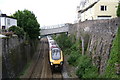
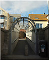
The railway slices through Teignmouth
Brunel's railway runs in a deep cutting through the town. It is crossed by 11 bridges in a distance of 1500 metres or so. Here, an eastbound Cross Country service passes under the Willow Street footbridge. The front of the train and the viewpoint, the Parson Street bridge, are just in square.
Update: the Fore Street bridge was replaced in February 2012. See Image and shared description.
Image: © Robin Stott
Taken: 20 May 2009
0.01 miles
2
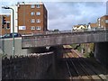
Bitton Park Road crosses the railway, Teignmouth
Just as Brunel's Great Western Railway cut a swathe through Teignmouth in the mid-19th century so, in the late 20th century a parallel swathe was cut for a road that would take traffic out of the town centre. In this it was successful but with brutal and incongruous effects on the townscape along the road. Note the footpath under the bridge. The view is from the Saxe Street crossing behind the library.
Image: © Robin Stott
Taken: 15 Jul 2010
0.01 miles
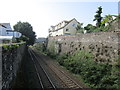
3
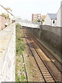
Railway cutting between buildings, Teignmouth
This is the main line railway which has come from Exeter, down the Exe, round the coast, and has just turned along the north bank of the Teign going to Newton Abbot and Plymouth. The harbour buildings and Teign are just beyond the buildings on the right. The bridge is a footbridge from Willow Street, with a footpath coming along beside the railway on the left of the photo.
Image: © David Hawgood
Taken: 14 Apr 2007
0.01 miles
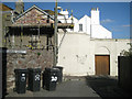
4
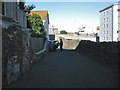
Exit from Mulberry Street, Teignmouth
Named on the local street map as Mulberry Street it looks like a private drive off Parson Street. A sign confirms that it is a public right of way. This area of Teignmouth has been fragmented by railway, road and bombing. Note the wall repaired in two stones, left. On the right are the refurbished Parson Street flats.
Image: © Robin Stott
Taken: 19 Aug 2012
0.01 miles
5

Refurbished wall and new street nameplate, corner of Mulberry Street, Teignmouth
The rounded lumps of red sandstone and purplish breccia in this wall, as in other old walls in Teignmouth, might have come from the beach, long before any sea walls or promenades were built. Not much of Mulberry Street is to be seen: it must have been severed when a tunnel west of the station was converted to the deep cutting seen today, perhaps in 1892 when standard gauge line was laid and the station rebuilt.
Image: © Robin Stott
Taken: 6 Jul 2013
0.01 miles
6
Railway footbridge, Teignmouth
Image: © Derek Harper
Taken: 28 Sep 2018
0.02 miles
7
The railway seen from Parson Street bridge
Looking westwards towards Newton Abbott.
Image: © Jonathan Thacker
Taken: 6 Sep 2014
0.02 miles
8

Parson Street flats, Teignmouth
The stone wall between the two blocks of flats on the right is above railway lines.
Image: © Jaggery
Taken: 21 Apr 2016
0.02 miles
9
Mulberry Street corner
Mulberry Street was severed by Brunel's Great Western Railway through the town. Here the south end of the street joins Custom House Hill. The north end of Mulberry Street was diverted to join Parson Street. Note the old walls of Teignmouth sandstone.
Image: © Robin Stott
Taken: 14 Sep 2011
0.02 miles
10
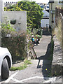
A glimpse of Mulberry Street
A fragment of old Teignmouth that may or may not be Mulberry Street.
The fabric of this part of the town has been disrupted by the nineteenth-century railway slicing through it, then World War II bombing and late twentieth-century road building and new residential development.
Image: © Robin Stott
Taken: 19 Aug 2012
0.02 miles