IMAGES TAKEN NEAR TO
Woodland, Ashburton, NEWTON ABBOT, TQ13 7JR
Introduction
This page details the photographs taken nearby to TQ13 7JR by members of the Geograph project.
The Geograph project started in 2005 with the aim of publishing, organising and preserving representative images for every square kilometre of Great Britain, Ireland and the Isle of Man.

There are currently over 7.5m images from over14,400 individuals and you can help contribute to the project by visiting https://www.geograph.org.uk
Image Map
Images are licensed for reuse under creativecommons.org/licenses/by-sa/2.0
Notes
- Clicking on the map will re-center to the selected point.
- The higher the marker number, the further away the image location is from the centre of the postcode.
Image Listing (11 Images Found)
Images are licensed for reuse under creativecommons.org/licenses/by-sa/2.0
Image
Details
Distance
1
Tor Farm
The only view of the farm buildings that I encountered.
Image: © Robin Stott
Taken: 22 Jun 2010
0.01 miles
2
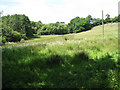
Rushy field, Hawkes
From the lane from Ashburton to Woodland as it crosses a small valley. Farm building at Tor can be seen through the trees.
Image: © Derek Harper
Taken: 12 Apr 2006
0.08 miles
3
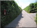
Long lane up to Whistley Hill Cross
Postbox number TQ13 148, opposite the entrance to Tor Farm.
Image: © Robin Stott
Taken: 22 Jun 2010
0.10 miles
4
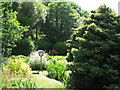
Stream garden, Higher Lake Farm
The stream runs down from the valley to the north Image (it's not shown on the 1:50,000 map). OS Explorer shows a chain of ponds continuing down the valley from Higher Lake Farm to Higher Lake Image
South Devon's climate and topography create very favourable conditions for domestic gardens. Everywhere, especially in remote valleys, householders create lush, intimate versions of paradise amid the large-scale landscape of farmed and forested whaleback hills.
Image: © Robin Stott
Taken: 22 Jun 2010
0.12 miles
5
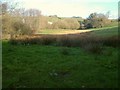
Wet meadow opposite Higher Lake Farm
A stream runs down the valley between Tor Farm and Hawkes Farm, goes under the lane behind the camera and sustains the stream garden of Higher Lake Farm Image Of the three, only Tor Farm appears to be a working farm still. OS Explorer shows a chain of ponds continuing down the valley from Higher Lake Farm to Higher Lake Image
Image: © Robin Stott
Taken: 22 Jun 2010
0.12 miles
6
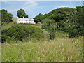
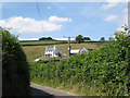
Hawkes Farm
It is difficult to reconcile this rather idyllic view with aerial photos, which show a large area of bare ground alongside what looks like a building site. One explanation would be that an extensive range of farm buildings has been demolished and the ground cleared while the farmhouse or farm cottages have been modernised, reroofed and extended at the back. This would square with the remark by the farmer at Wickeridge Farm that they had taken over some Hawkes Farm land Image
Image: © Robin Stott
Taken: 22 Jun 2010
0.13 miles
7
Farmland above Tor
Seen from White Eagle. This is the hillside behind the scene in Image
Image: © Derek Harper
Taken: 12 Apr 2006
0.16 miles
8
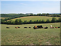
Mixed herd of cattle near Dipwell
The shapely green hillside is the north end of the ridge west of Higher Lake Image In the distance, centre, is Torcorn Hill Image
Image: © Robin Stott
Taken: 22 Jun 2010
0.17 miles
9
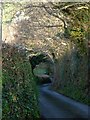
Lane at White Eagle
Image: © Derek Harper
Taken: 12 Apr 2006
0.19 miles
10
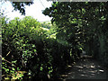
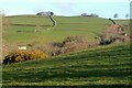
Lane down to Higher Lake Farm
Behind the camera the lane climbs steeply to White Eagle. From here there is a glimpse of land around Tor Farm.
Image: © Robin Stott
Taken: 22 Jun 2010
0.21 miles