IMAGES TAKEN NEAR TO
Buckingham Orchard, NEWTON ABBOT, TQ13 0EW
Introduction
This page details the photographs taken nearby to Buckingham Orchard, TQ13 0EW by members of the Geograph project.
The Geograph project started in 2005 with the aim of publishing, organising and preserving representative images for every square kilometre of Great Britain, Ireland and the Isle of Man.

There are currently over 7.5m images from over14,400 individuals and you can help contribute to the project by visiting https://www.geograph.org.uk
Image Map
Images are licensed for reuse under creativecommons.org/licenses/by-sa/2.0
Notes
- Clicking on the map will re-center to the selected point.
- The higher the marker number, the further away the image location is from the centre of the postcode.
Image Listing (57 Images Found)
Images are licensed for reuse under creativecommons.org/licenses/by-sa/2.0
Image
Details
Distance
1
Bellamarsh Lane
Followed by Hennock Footpath 19, this track leads down to the River Teign where there is a footbridge. But its original course to Bellamarsh is then truncated by the A38.
Image: © Derek Harper
Taken: 17 Feb 2009
0.06 miles
2
Bellamarsh Lane
An almost identical shot to Image, but with a more autumnal air.
Image: © Derek Harper
Taken: 12 Dec 2010
0.06 miles
4
Former Toll House, Teignbridge
Tollgate Cottage. On the NW side of the B3344 (ex A38), Plymouth Road, Chudleigh Knighton, TQ13 0EN.
Image: © Milestone Society
Taken: Unknown
0.09 miles
5
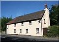
Knighton toll house, Chudleigh Knighton
Toll House by the B3344, in the parish of Hennock (Teignbridge District), Toll Gate Cottage, Plymouth Road, Chudleigh Knighton, TQ13 0EN.
Devon & Dartmoor HER.
HER Number: MDV56669 https://www.heritagegateway.org.uk/Gateway/Results_Single.aspx?uid=MDV56669&resourceID=104
Surveyed
Milestone Society National ID: DV.CHD
Image: © Alan Rosevear
Taken: 25 Jun 2010
0.10 miles
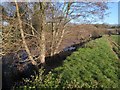
6

Alder catkin buds by the Teign
A little way along the bank from Image The male catkins themselves will be yellow. Last year's cone-like female catkins are also visible.
Image: © Derek Harper
Taken: 17 Feb 2009
0.10 miles
7
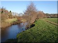
River Teign at Chudleigh Knighton
Like Image, a view upstream from the partly undercut riverbank near Kingsteignton Footpath 6 (the line of the path officially runs along the foot of the A38 embankment, but I can't imagine anyone would walk there in preference to the delightful riverside). Alders are showing a chocolate-brown as their catkins come out.
Image: © Derek Harper
Taken: 12 Dec 2010
0.10 miles
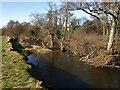
8
River Teign at Chudleigh Knighton
See Image; this was taken a little further downstream (and looking upstream), beside a group of alders.
Image: © Derek Harper
Taken: 12 Dec 2010
0.10 miles
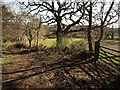
9

River Teign at Chudleigh Knighton
A view in the opposite direction to Image, showing the trees and gravel bank in the river, and Image just upstream.
Image: © Derek Harper
Taken: 17 Feb 2009
0.10 miles
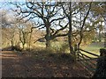
10
River Teign at Chudleigh Knighton
This view looks down a fairly straight stretch of river, trending slightly left, so I am not sure whether the row of trees marooned in mid stream represents a former line of the bank (they are not on the outside of a bend). If so, there has been some dramatic cutting back in recent years.
Image: © Derek Harper
Taken: 17 Feb 2009
0.10 miles