IMAGES TAKEN NEAR TO
Abbotskerswell, NEWTON ABBOT, TQ12 5PF
Introduction
This page details the photographs taken nearby to TQ12 5PF by members of the Geograph project.
The Geograph project started in 2005 with the aim of publishing, organising and preserving representative images for every square kilometre of Great Britain, Ireland and the Isle of Man.

There are currently over 7.5m images from over14,400 individuals and you can help contribute to the project by visiting https://www.geograph.org.uk
Image Map
Images are licensed for reuse under creativecommons.org/licenses/by-sa/2.0
Notes
- Clicking on the map will re-center to the selected point.
- The higher the marker number, the further away the image location is from the centre of the postcode.
Image Listing (73 Images Found)
Images are licensed for reuse under creativecommons.org/licenses/by-sa/2.0
Image
Details
Distance
1
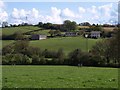
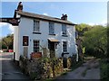
Manor Farm
Looking across the valley of the Abbotskerswell stream from Vicarage road, to the farm buildings on Bitney Lane. The house on the right is shown in Image, and the easting gridline runs a couple of metres inside its garden fence.
Image: © Derek Harper
Taken: 1 May 2008
0.05 miles
2
Edge of Abbotskerswell
The buildings left of centre appear in Image On the right is the cluster of buildings around Image The view is from Priory Road at the end of Image
Image: © Derek Harper
Taken: 6 Dec 2009
0.06 miles
3
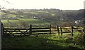
Countryside east of Abbotskerswell
This wide angle view encompasses the scenes in Image and Image and is taken from the same spot on Vicarage Road.
Image: © Derek Harper
Taken: 1 May 2008
0.08 miles
4

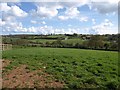
Countryside south of Abbotskerswell
The tree is on the lane from Greatoak Cross to Abbotskerswell. In the distance, to the left of it, is The Priory http://www.geograph.org.uk/gridref/SX8669?centi=SX864690 .
Image: © Derek Harper
Taken: 1 Jun 2021
0.09 miles
5
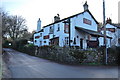
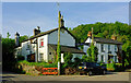
The Butchers Arms, Abbotskerswell
One of the local public houses in Abbotskerswell. This one is just a few yards from Image
Image: © Paul Hutchinson
Taken: 18 Jan 2009
0.09 miles
6
Former Butchers Arms, Abbotskerswell
An update to Image and Image "This pub closed c2013 and is to be converted into low cost housing" http://www.closedpubs.co.uk/devon/abbotskerswell_butchers.html . Apart from the sadly dilapidated state of the former pub, the most pronounced change is the ivy on the telegraph poles. On the right is Brook Cottage. The lane to Stoneycombe climbs to the left; Abbotskerswell bridleway 8 heads right along Slade Lane.
Image: © Derek Harper
Taken: 1 Jun 2021
0.10 miles
7
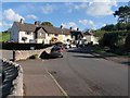
Barnfield Terrace, Abbotskerswell
A modern terrace on Slade Lane at the southern end of the village. On the left is the vehicle entrance to the recreation ground and play area.
Image: © Derek Harper
Taken: 1 May 2008
0.11 miles
8
Butcher's Arms, Abbotskerswell
The right-hand of the two buildings shown in Image, with the bridleway Slade Lane running off to the right.
Image: © Derek Harper
Taken: 1 May 2008
0.11 miles
9
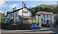
Butcher's Arms, Abbotskerswell
This old pub is at the southern edge of the village. The entrance to the car park is between the two buildings under a sign. On the left is the lane to Kingskerswell; to the right is Slade Lane, a bridleway towards Whiddon.
Image: © Derek Harper
Taken: 1 May 2008
0.11 miles
10
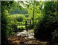
By Slade Lane
A scene by Abbotskerswell bridleway 8.
Image: © Derek Harper
Taken: 1 Jun 2021
0.11 miles