IMAGES TAKEN NEAR TO
Woodland Avenue, NEWTON ABBOT, TQ12 5BB
Introduction
This page details the photographs taken nearby to Woodland Avenue, TQ12 5BB by members of the Geograph project.
The Geograph project started in 2005 with the aim of publishing, organising and preserving representative images for every square kilometre of Great Britain, Ireland and the Isle of Man.

There are currently over 7.5m images from over14,400 individuals and you can help contribute to the project by visiting https://www.geograph.org.uk
Image Map
Images are licensed for reuse under creativecommons.org/licenses/by-sa/2.0
Notes
- Clicking on the map will re-center to the selected point.
- The higher the marker number, the further away the image location is from the centre of the postcode.
Image Listing (39 Images Found)
Images are licensed for reuse under creativecommons.org/licenses/by-sa/2.0
Image
Details
Distance
1
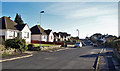
Woodland Avenue, Kingskerswell
The junction on the right is Park Road.
Image: © Richard Dorrell
Taken: 19 Jan 2011
0.03 miles
2
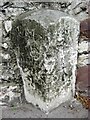
Old Boundary Marker on Newton Road, Kingskerswell parish
Parish Boundary Marker set in a front garden wall on the west side of Newton Road almost opposite a petrol station, 200 metres south of the junction with Cole's Lane. Until 1935, when both were combined in Kerswells parish, the stone was on the boundary of Kingskerswell and Abbotskerswell. In 1984 the two parishes were separated again, but with a different boundary and the stone is now entirely in Kingskerswell parish. Inscribed KINGS / CARS / WELL and ABBOTS / (CARS) / WELL on adjacent faces.
Milestone Society National ID: DV_TQEX05pb
Image: © T Jenkinson
Taken: 13 May 2011
0.04 miles
3
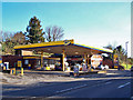
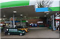
Service Station and shop, Newton Road
Located close to the junction with Furzedown Road.
Image: © Richard Dorrell
Taken: 19 Jan 2011
0.06 miles
5
Newton Road, Kingskerswell
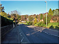
The junction in the centre of the picture is Lyndhurst Avenue. This is the main route connecting Torquay and Newton Abbot. It is seen here in a rare almost traffic-free moment. In summer, it is not unusual for there to be a solid line of barely moving traffic in both directions.
Image: © Richard Dorrell
Taken: 19 Jan 2011
0.06 miles
6

Newton Road passing Harvest Energy filling station
Image: © Roy Hughes
Taken: 9 Aug 2025
0.06 miles
8
Lyndhurst Avenue, Kingskerswell
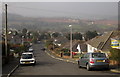
The road is shown from the lower end in Image The view from this top end looks across the village to where preparations are being made to built a bypass. http://southdevonlinkroad.co.uk/before-after/ shows (about halfway down the page) three views from approximately this point, including predicted views for 1 and 15 years after the new road is built.
Image: © Derek Harper
Taken: 5 Mar 2013
0.09 miles
9
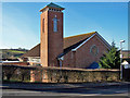
St Gregory's Catholic Church, Kingskerswell
The church is located in Coles Lane.
There was a major fire at this church on May 13, 1976, which caused massive damage. Local parishioners spent the next few years, planning and fundraising for the restoration of their church. Building work costing £140,000 started in August 1979 and was completed in May the following year. The old bell, which had hung on in the blazing tower, had been cracked by the heat so a spare bell from the parish church of St Mary's was transferred there – by helicopter. The restoration gave the church a modern interior, with a hall and meeting rooms created on the first floor. The congregation now faces east as is usual with churches, rather than south as before. Like most churches today, it is locked when not in use.
Image: © Richard Dorrell
Taken: 19 Jan 2011
0.10 miles