IMAGES TAKEN NEAR TO
Woodlands Copse, NEWTON ABBOT, TQ12 3QL
Introduction
This page details the photographs taken nearby to Woodlands Copse, TQ12 3QL by members of the Geograph project.
The Geograph project started in 2005 with the aim of publishing, organising and preserving representative images for every square kilometre of Great Britain, Ireland and the Isle of Man.

There are currently over 7.5m images from over14,400 individuals and you can help contribute to the project by visiting https://www.geograph.org.uk
Image Map
Images are licensed for reuse under creativecommons.org/licenses/by-sa/2.0
Notes
- Clicking on the map will re-center to the selected point.
- The higher the marker number, the further away the image location is from the centre of the postcode.
Image Listing (22 Images Found)
Images are licensed for reuse under creativecommons.org/licenses/by-sa/2.0
Image
Details
Distance
1
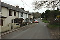
Terrace, Higher Sandygate
A terrace of cottages that would have been built for clay miners.
Image: © Derek Harper
Taken: 18 Mar 2017
0.03 miles
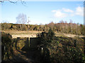
2
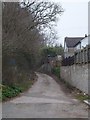
Old Exeter Road joins Higher Sandygate
The old Exeter Road, a Roman road, continues north as a track behind the photographer. On the left are the backs of properties in Woodlands. Higher Sandygate bears right as a lane towards Fosterville Image
Image: © Robin Stott
Taken: 26 Feb 2010
0.04 miles
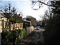
4
Minor track in Higher Sandygate
This cul-de-sac is aligned with the road through Higher Sandygate; the latter is marked as a Roman Road; was this also part of it?
Image: © David Smith
Taken: 13 Mar 2012
0.06 miles
5
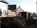
Land being cleared north of Woodlands
The land is to the east of the track that is the old Exeter Road off Higher Sandygate. New houses in Woodlands are down to the right. Not far beyond the fence and trees is the cutting of the A380 north of Kingsteignton.
Image: © Robin Stott
Taken: 26 Feb 2010
0.09 miles
6
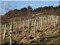
Young trees above former sand quarry
This tree-planting is on the far slopes in Image Staked tree shelters help support young trees and protect their vulnerable bark from grey squirrels and particularly voles. This looks like mollycoddling though. The mature trees are in the vicinity of Sands Copse (with some sand visible). Being conifers they must have been planted on the site of a deciduous coppice.
Image: © Robin Stott
Taken: 26 Feb 2010
0.10 miles
8
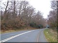
B3195 in Stony Copse
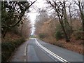
The old A380 main road north of Kingsteignton. Its main function is as the southbound slip road from the modern dual carriageway leading into the village - that's the right-hand lane here. The left-hand lane serves as access for houses on this stretch of road and in Combe.
Image: © Derek Harper
Taken: 18 Mar 2006
0.15 miles
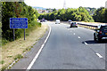
9

Slip road, Sandygate
A slip road from the B3185 joins the A380 dual carriageway, with cars heading for Torbay swinging round a 180° bend to be faced with a very short amount of slip lane to join a busy and fast main road. The woodland is an isolated chunk of Stony Copse.
Image: © Derek Harper
Taken: 22 Apr 2017
0.17 miles
10
B3195 in Stony Copse
Looking in the other direction from down the former main road.
Image: © Derek Harper
Taken: 18 Mar 2006
0.17 miles