IMAGES TAKEN NEAR TO
Rattery, SOUTH BRENT, TQ10 9LF
Introduction
This page details the photographs taken nearby to TQ10 9LF by members of the Geograph project.
The Geograph project started in 2005 with the aim of publishing, organising and preserving representative images for every square kilometre of Great Britain, Ireland and the Isle of Man.

There are currently over 7.5m images from over14,400 individuals and you can help contribute to the project by visiting https://www.geograph.org.uk
Image Map
Images are licensed for reuse under creativecommons.org/licenses/by-sa/2.0
Notes
- Clicking on the map will re-center to the selected point.
- The higher the marker number, the further away the image location is from the centre of the postcode.
Image Listing (31 Images Found)
Images are licensed for reuse under creativecommons.org/licenses/by-sa/2.0
Image
Details
Distance
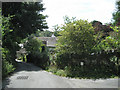
1
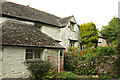
West Mead, Rattery
A listed house https://historicengland.org.uk/listing/the-list/list-entry/1107393?section=official-list-entry on a steep lane at the north end of the village. See also Image
Image: © Derek Harper
Taken: 1 Sep 2022
0.00 miles
2
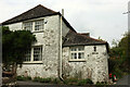
West Mead, Rattery
The south side of the listed house shown in Image https://historicengland.org.uk/listing/the-list/list-entry/1107393?section=official-list-entry Very tricky to get the whole building in one frame.
Image: © Derek Harper
Taken: 1 Sep 2022
0.01 miles
3
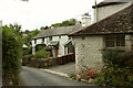
Houses, Rattery
Image: © Derek Harper
Taken: 1 Sep 2022
0.02 miles
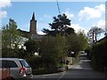
4
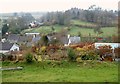
View over Rattery
From the churchyard of St Mary's, with houses and small fields on the north side of the village. Image shows a similar view in much better weather.
Image: © Derek Harper
Taken: 12 Mar 2006
0.06 miles
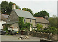
6

The Vines, Rattery
"House reduced in size to form cottage. Circa early C16 ..." https://historicengland.org.uk/listing/the-list/list-entry/1107394?section=official-list-entry . This attractive cottage sits in a valley close to the stream.
Image: © Derek Harper
Taken: 1 Sep 2022
0.07 miles
7
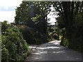
Road cutting on the east of Rattery
The village lies in a valley and the principal road from the east descends the valley side through this cutting
Image: © David Smith
Taken: 6 May 2012
0.07 miles
8
The Plains, Rattery
Brook Cottage and Brookside were originally one house https://historicengland.org.uk/listing/the-list/list-entry/1308481?section=official-list-entry . On the left is a glimpse of Image
Image: © Derek Harper
Taken: 1 Sep 2022
0.07 miles
9
Rattery village bridge
The village lies in the valley of the Bidwell Brook which is crossed by the bridge seen here. The church is on the opposite side of the valley.
Image: © David Smith
Taken: 6 May 2012
0.10 miles
10
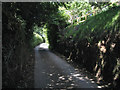
Sunken lane north out of Rattery
The lane leads to Pennywell and Lower Dean. At upper right is the garden of a new house on the edge of the village.
Image: © Robin Stott
Taken: 28 Jul 2010
0.10 miles