IMAGES TAKEN NEAR TO
SOUTH BRENT, TQ10 9EB
Introduction
This page details the photographs taken nearby to TQ10 9EB by members of the Geograph project.
The Geograph project started in 2005 with the aim of publishing, organising and preserving representative images for every square kilometre of Great Britain, Ireland and the Isle of Man.

There are currently over 7.5m images from over14,400 individuals and you can help contribute to the project by visiting https://www.geograph.org.uk
Image Map
Images are licensed for reuse under creativecommons.org/licenses/by-sa/2.0
Notes
- Clicking on the map will re-center to the selected point.
- The higher the marker number, the further away the image location is from the centre of the postcode.
Image Listing (11 Images Found)
Images are licensed for reuse under creativecommons.org/licenses/by-sa/2.0
Image
Details
Distance
1
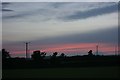
Gisperdown, Dartmoor
The hedges and electricity supply lines near Gisperdown are silhouetted by this sunset.
Image: © Adrian Platt
Taken: 8 Jul 2010
0.11 miles
2
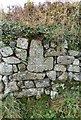
Old Wayside Cross near Gisperdown Farm
Gisperdown Cross, old head by the UC road, in parish of South Brent (South Hams District), Gisperdown Farm, built into wall at entrance, to right of cattle grid.
Surveyed
Milestone Society National ID: DVSH_SBR02
Image: © Alan Rosevear
Taken: 17 Nov 2012
0.16 miles
3
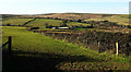
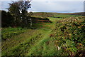
Bridleway past Dockwell Farm
South Brent bridleway 28 heads along the side of the field, formerly an enclosed stroll for livestock (field boundaries have been removed). Dockwell Farm (in Image) occupies a side valley of the Harbourne valley on the right. In the centre background is access land on the open moor, which the bridleway leads to.
Image: © Derek Harper
Taken: 22 Mar 2020
0.19 miles
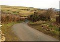
4
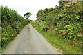
Lane passing Bloody Pool Brake
Looking in the opposite direction to Image] along the lane to Gidley Bridge.
Image: © Derek Harper
Taken: 1 Sep 2022
0.20 miles
5
Bridleway to the open moor
Crossing several fields close to Dockwell Farm before entering the open moor on the lower slopes of Dockwell Ridge.
Image: © jeff collins
Taken: 7 Oct 2014
0.21 miles
6
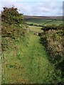
Bridleway to Dockwell Ridge
South Brent Bridleway 28 leaves the open area shown in Image through this gate, to cross fields near Dockwell Farm on its way to the open moor.
Image: © Derek Harper
Taken: 29 Aug 2009
0.21 miles
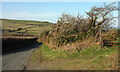
7
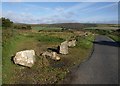
Roadside area, near Gisperdown
Large blocks of stone dissuade parking on this otherwise convenient spot where South Brent Bridleway 28 begins. See also Image
Image: © Derek Harper
Taken: 29 Aug 2009
0.21 miles
8
High point on the lane from Bloody Pool to Gidley Bridge
Image: © David Gearing
Taken: 2 Oct 2014
0.21 miles
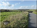
9
Lane to Gidley Bridge
From the highest point on the lane between Image and Image Down in the Harbourne River valley are buildings at Reddacleave.
The rocks on the left indicate that either the authorities or local farmers have tired of cars getting bogged down in the adjoining little tongue of open land (doubtless an animal gathering place). From it, South Brent Bridleway 28 heads across fields onto Dartmoor near Dockwell Ridge.
Image: © Derek Harper
Taken: 15 Dec 2008
0.24 miles
10
Gateway by lane to Gidley Bridge
The gate from which Image] and Image] were taken. The lane is dropping into Harbourne River valley. On the extreme leave is Reddacleave.
Image: © Derek Harper
Taken: 22 Mar 2020
0.24 miles