IMAGES TAKEN NEAR TO
Barnhorn Road, BEXHILL-ON-SEA, TN39 4QG
Introduction
This page details the photographs taken nearby to Barnhorn Road, TN39 4QG by members of the Geograph project.
The Geograph project started in 2005 with the aim of publishing, organising and preserving representative images for every square kilometre of Great Britain, Ireland and the Isle of Man.

There are currently over 7.5m images from over14,400 individuals and you can help contribute to the project by visiting https://www.geograph.org.uk
Image Map (Loading...)


Getting Data...Please wait
Leaflet Map data © OpenStreetMap
Images are licensed for reuse under creativecommons.org/licenses/by-sa/2.0
Notes
- Clicking on the map will re-center to the selected point.
- The higher the marker number, the further away the image location is from the centre of the postcode.
Image Listing (15 Images Found)
Images are licensed for reuse under creativecommons.org/licenses/by-sa/2.0
Image
Details
Distance
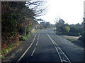
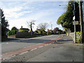
2
A259 Barnhorn Road junction with Sandhurst Lane
Image: © Stuart Logan
Taken: 27 May 2012
0.08 miles
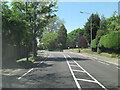
4
Barnhorn Road, Cooden, East Sussex
Image: © Oast House Archive
Taken: 25 Oct 2008
0.12 miles
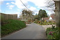
5
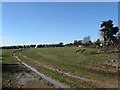
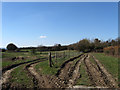
Old Town Field
The name of the field according to the 1843 tithe map. The name indicates that the field was near or the site of the former settlement of Barnhorn. The manor of the same name had its boundaries drawn out by a charter of 772 and by the medieval period had fallen into ownership of the monks of Battle Abbey. It was they who began reclamation of the marshes to the south and built the settlement to provide housing for those who needed to build and maintain the dykes and sea walls as well as those who were to farm it. The settlement itself lasted until the 14th century when it disappeared probably a mixture of the Black Death, coastal storms and a change in agriculture away from cereal production to sheep farming that was far less labour intensive. Only the name remains as a reminder.
Image: © Simon Carey
Taken: 7 Mar 2010
0.12 miles
6
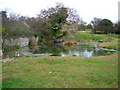
Pond, Barnhorne Manor Farm
The wall divides it from some outbuildings whilst beyond the far gate are the gardens of the houses in Barnhorn Road.
Image: © Simon Carey
Taken: 22 Feb 2008
0.13 miles
7
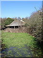
Disused Barn near Barnhorne Manor
Looking inside Image at a very dilapidated cow shed. The ground by the gate is also very waterlogged.
Image: © Simon Carey
Taken: 7 Mar 2010
0.14 miles
8
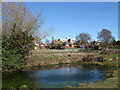
Pond near Barnhorne Manor
One of a number next to the footpath from the manor house to a disused barn which was also once the location of the settlement of Barnhorne which existed from the 12th to 14th centuries. The current houses and flats are on Barnhorn Road, the A259.
Image: © Simon Carey
Taken: 7 Mar 2010
0.14 miles
9

Disused Barn near Barnhorne Manor
Most likely part of the manor's farm. A flint wall remains but the interior is overgrown and the buildings look very dilapidated.
Image: © Simon Carey
Taken: 7 Mar 2010
0.14 miles
10
Toll Field
The name of the field according to the 1843 tithe map and also the site of the former settlement of Barnhorne that existed between the 13th and 14th centuries before a combination of disease, coastal storms and change in marsh agriculture from cereal production to sheep caused depopulation and eventual desertion.
Image: © Simon Carey
Taken: 7 Mar 2010
0.15 miles